Our website is made possible by displaying online advertisements to our visitors.
Please consider supporting us by disabling your ad blocker.
Karangahake Gorge

37°25′25″S 175°43′32″E / 37.423676°S 175.725514°E


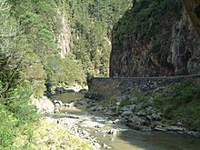
The Karangahake Gorge lies between the Coromandel and Kaimai ranges, at the southern end of the Coromandel Peninsula in New Zealand's North Island. A sharply winding canyon, it was formed by the Ohinemuri River. State Highway 2 passes through this gorge between the towns of Paeroa, Waikino and Waihi. This road is the main link between the Waikato region and the Bay of Plenty.
The East Coast Main Trunk Railway used to run through the gorge until it was bypassed by the Kaimai Deviation - and the Karangahake Gorge section is now a combined walkway and cycleway, part of the Hauraki Rail Trail.

There are also several walks and tracks starting at the Karangahake Reserve car park and picnic area; ranging from 30 minutes to over 2 hours.
Previous Page Next Page


