Our website is made possible by displaying online advertisements to our visitors.
Please consider supporting us by disabling your ad blocker.
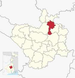
Katwa I
Katwa I | |
|---|---|
Community Development Block | |
 Location in West Bengal | |
| Coordinates: 23°35′46″N 88°05′02″E / 23.59611°N 88.08389°E | |
| Country | |
| State | West Bengal |
| District | Purba Bardhaman |
| Parliamentary constituency | Bardhaman Purba, Bolpur |
| Assembly constituency | Katwa, Ketugram, Mongalkot |
| Area | |
• Total | 65.23 sq mi (168.94 km2) |
| Elevation | 62 ft (19 m) |
| Population (2011) | |
• Total | 173,087 |
| • Density | 2,700/sq mi (1,000/km2) |
| Time zone | UTC+5.30 (IST) |
| PIN | 713130 (Katwa) 713502 (Dainhat) |
| Telephone/STD code | 03453 |
| Vehicle registration | WB-37,WB-38,WB-41,WB-42,WB-44 |
| Literacy Rate | 70.36 per cent |
| Website | http://purbabardhaman.gov.in/ |
Katwa I is a community development block that forms an administrative division in Katwa subdivision of Purba Bardhaman district in the Indian state of West Bengal.
Previous Page Next Page


