Our website is made possible by displaying online advertisements to our visitors.
Please consider supporting us by disabling your ad blocker.
Kauhajoki
You can help expand this article with text translated from the corresponding article in Finnish. (June 2023) Click [show] for important translation instructions.
|
Kauhajoki | |
|---|---|
Town | |
| Kauhajoen kaupunki Kauhajoki stad | |
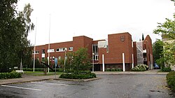
 Kauhajoki Town Hall | |
 Location of Kauhajoki in Finland | |
| Coordinates: 62°25′55″N 22°10′46″E / 62.43194°N 22.17944°E | |
| Country | |
| Region | Southern Ostrobothnia |
| Sub-region | Suupohja sub-region |
| Charter | 1868 |
| Town privileges | 2001 |
| Government | |
| • Town manager | Niku Latva-Pukkila |
| Area (2018-01-01)[1] | |
• Total | 1,315.54 km2 (507.93 sq mi) |
| • Land | 1,298.98 km2 (501.54 sq mi) |
| • Water | 16.46 km2 (6.36 sq mi) |
| • Rank | 55th largest in Finland |
| Population (2024-10-31)[2] | |
• Total | 12,572 |
| • Rank | 80th largest in Finland |
| • Density | 9.68/km2 (25.1/sq mi) |
| • Demonym | Kauhajokinen (Finnish) |
| Population by native language | |
| • Finnish | 96.1% (official) |
| • Swedish | 0.4% |
| • Others | 3.5% |
| Population by age | |
| • 0 to 14 | 15.1% |
| • 15 to 64 | 57% |
| • 65 or older | 27.9% |
| Time zone | UTC+02:00 (EET) |
| • Summer (DST) | UTC+03:00 (EEST) |
| Website | kauhajoki |
Kauhajoki (Finnish pronunciation: [ˈkɑu̯hɑˌjoki]; lit. “Scoop River”) is a town and municipality of Finland. It is located in the province of Western Finland and is part of the Southern Ostrobothnia region, 59 kilometres (37 mi) southwest of the city of Seinäjoki. The population of Kauhajoki is 12,572 (31 October 2024)[2] and the municipality covers an area of 1,298.98 km2 (501.54 sq mi) of which 16.46 km2 (6.36 sq mi) is inland water (1 January 2018).[1] The population density is 9.68/km2 (25.1/sq mi). The town is unilingually Finnish.
The neighboring municipalities of Kauhajoki are Isojoki in the southwest, Kankaanpää in the south, Karijoki in the west, Karvia in the southeast, Kurikka in the north and Teuva in the west.[5] Kauhajoki is the center of the Suupohja sub-region.[6]
- ^ a b "Area of Finnish Municipalities 1.1.2018" (PDF). National Land Survey of Finland. Retrieved 30 January 2018.
- ^ a b c "Finland's preliminary population figure was 5,635,560 at the end of October 2024". Population structure. Statistics Finland. 19 November 2024. ISSN 1797-5395. Retrieved 22 November 2024.
- ^ "Population according to age (1-year) and sex by area and the regional division of each statistical reference year, 2003–2020". StatFin. Statistics Finland. Retrieved 2 May 2021.
- ^ a b "Luettelo kuntien ja seurakuntien tuloveroprosenteista vuonna 2023". Tax Administration of Finland. 14 November 2022. Retrieved 7 May 2023.
- ^ "Kauhajoki · Kauhajoki, Suomi". Retrieved 23 September 2021.
- ^ "Kauhajoki - Yritykset ja työnantajat - Finder.fi". Finder.fi (in Finnish). Retrieved 23 September 2021.
Previous Page Next Page


