Our website is made possible by displaying online advertisements to our visitors.
Please consider supporting us by disabling your ad blocker.
Kendujhar district
Kendujhar district
Keonjhar | |
|---|---|
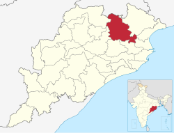
 Location in Odisha | |
| Coordinates: 21°37′59″N 85°36′00″E / 21.633°N 85.6°E | |
| Country | India |
| State | Odisha |
| Headquarters | Kendujhar |
| Government | |
| • Collector & District Magistrate | Vishal Singh, IAS |
| • Divisional Forest Officer Cum Wildlife Warden | Dhanraj Hanumant Dhamdhere, IFS |
| • Superintendent of Police | Kusalkar Nitin Dagudu, IPS |
| Area | |
• Total | 8,303 km2 (3,206 sq mi) |
| Elevation | 480 m (1,570 ft) |
| Population (2011)[1] | |
• Total | 1,801,733 |
| • Rank | 8 |
| • Density | 220/km2 (560/sq mi) |
| Languages | |
| • Official | Odia, English |
| • Local | Ho, Munda, Juang[2] |
| Time zone | UTC+5:30 (IST) |
| PIN | 758 xxx |
| Vehicle registration | OD-09 |
| Sex ratio | 0.987 ♂/♀ |
| Literacy | 69% |
| Lok Sabha constituency | Keonjhar(ST) |
| Vidhan Sabha constituency | 7 |
| Climate | Aw (Köppen) |
| Precipitation | 1,535.5 millimetres (60.45 in) |
| Website | kendujhar |
| This article is part of a series on |
| Odisha |
|---|
 |
| Governance |
| Topics |
|
Districts Divisions |
| GI Products |
|
|
Kendujhar district, also known as Keonjhar district, is an administrative district of Odisha. The district is one of the fifth Scheduled Areas of Odisha.[3][4][5][6] The town of Kendujhar (or Kendujhargarh) is the district headquarters. The district has three sub-divisions, Anandapur, Champua, and Kendujhar.[7]
- ^ Cite error: The named reference
districtcensuswas invoked but never defined (see the help page). - ^ "Tribals seek official tag for Ho language". 27 October 2018.
- ^ "Vikaspedia Domains".
- ^ "Ministry of Tribal Affairs, Government of India".
- ^ [1][dead link]
- ^ "ST & SC Development, Minorities & Backward Classes Welfare Department:: Government of Odisha".
- ^ "Declaration of 5th Schedule". Retrieved 3 July 2018.
Previous Page Next Page


