Our website is made possible by displaying online advertisements to our visitors.
Please consider supporting us by disabling your ad blocker.
Kent
Kent | |
|---|---|
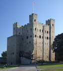
The White Cliffs of Dover, stained glass depicting Thomas Becket in Canterbury Cathedral, and Rochester Castle | |
| Coordinates: 51°12′N 0°42′E / 51.200°N 0.700°E | |
| Sovereign state | United Kingdom |
| Constituent country | England |
| Region | South East |
| Established | Ancient |
| Time zone | UTC+0 (GMT) |
| • Summer (DST) | UTC+1 (BST) |
| UK Parliament | List of MPs |
| Police | Kent Police |
| Ceremonial county | |
| Lord Lieutenant | Annabel Campbell, the Lady Colgrain |
| High Sheriff | Mrs Remony Millwater[1] (2020/21) |
| Area | 3,738 km2 (1,443 sq mi) |
| • Rank | 10th of 48 |
| Population (2022)[2] | 1,875,893 |
| • Rank | 7th of 48 |
| Density | 502/km2 (1,300/sq mi) |
| Ethnicity | 93.7% White (89.1% White British)[3] |
| Non-metropolitan county | |
| County council | Kent County Council |
| Control | Conservative |
| Admin HQ | Maidstone |
| Area | 3,544 km2 (1,368 sq mi) |
| • Rank | 6th of 21 |
| Population (2022)[4] | 1,593,191 |
| • Rank | 1st of 21 |
| Density | 449/km2 (1,160/sq mi) |
| ISO 3166-2 | GB-KEN |
| GSS code | E10000016 |
| ITL | UKJ42 |
| Website | kent |
| Districts | |
 Districts of Kent Unitary County council area | |
| Districts | |
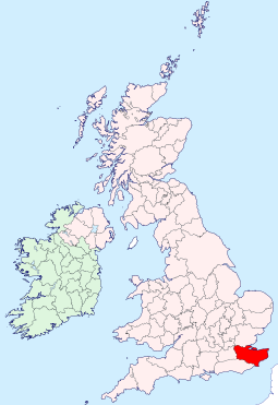
Kent is a ceremonial county in South East England. It is bordered by Essex across the Thames Estuary to the north, the Strait of Dover to the south-east, East Sussex to the south-west, Surrey to the west, and Greater London to the north-west. The county town is Maidstone.
The county has an area of 3,544 square kilometres (1,368 sq mi) and had population of 1,875,893 in 2022, making it the fifth most populous county in England. The north of the county contains a conurbation which includes the towns of Chatham, Gillingham, and Rochester. Other large towns are Maidstone and Ashford, and the borough of Canterbury holds city status. For local government purposes Kent consists of a non-metropolitan county, with twelve districts, and the unitary authority area of Medway. The county historically included south-east Greater London, and is one of the home counties.
The north of Kent is a plain bordering the Thames Estuary. South of this is the North Downs, a chalk downland ridge which crosses the county from north-west to south-east and which forms dramatic chalk cliffs, including the White Cliffs of Dover, where it meets the English Channel.[5] The south-west of the county contains part of the Greensand Ridge and the Weald, the area between the North and South Downs.[6][7][8] The south-east of the county contains the low-lying Romney Marsh.[9] The North Downs and High Weald have been designated national landscapes. The geography of the county lends itself to the cultivation of fruit orchards, and it has been nicknamed "the Garden of England".[10] In north-west Kent, industries include aggregate building material extraction, printing, and scientific research. Coal mining has also played its part in the county's industrial heritage.
Kent's location between London and the Strait of Dover, the narrowest crossing point between England and mainland Europe, has led to the county being the point of entry for many prominent figures and groups in British history. It was one of the first British territories to be settled by Germanic tribes, most notably the Jutes, following the withdrawal of the Romans.[11] In the 6th century, Saint Augustine landed in the county to begin the conversion of England to Christianity and became the first archbishop of Canterbury; Canterbury Cathedral is now a World Heritage Site. England relied on the county's ports to provide warships through much of its history; the Cinque Ports in the 10th[12]–14th centuries and Chatham Dockyard in the 16th–20th centuries were of particular importance. Dover Castle has been described as the "key of England" due to its strategic significance.[13]
- ^ "No. 62943". The London Gazette. 13 March 2020. p. 5161.
- ^ "Mid-2022 population estimates by Lieutenancy areas (as at 1997) for England and Wales". Office for National Statistics. 24 June 2024. Retrieved 26 June 2024.
- ^ "2011 Census: Cultural diversity in Kent" (PDF). Kent City Council. Archived (PDF) from the original on 5 November 2021. Retrieved 18 October 2021.
- ^ "Mid-Year Population Estimates, UK, June 2022". Office for National Statistics. 26 March 2024. Retrieved 3 May 2024.
- ^ "North Downs". Natural England. Retrieved 7 January 2025.
- ^ "Wealden Greensand". Natural England. Retrieved 7 January 2025.
- ^ "Low Weald". Natural England. Retrieved 7 January 2025.
- ^ "High Weald". Natural England. Retrieved 7 January 2025.
- ^ "Romney Marshes". Natural England. Retrieved 7 January 2025.
- ^ Wainwright, Martin (1 June 2006). "Kent loses its Garden of England title to North Yorkshire". The Guardian. ISSN 0261-3077. Archived from the original on 13 January 2022. Retrieved 28 May 2023.
- ^ "Kent | county, England, United Kingdom". Encyclopedia Britannica. Archived from the original on 22 April 2018. Retrieved 1 January 2020.
- ^ G. O. Sayles, The Medieval Foundations of England (London 1967). p. 186.
- ^ "How Dover Castle became the Key of England – the Great Siege of 1216". English Heritage. 20 July 2016. Retrieved 7 January 2025.
Previous Page Next Page


