Our website is made possible by displaying online advertisements to our visitors.
Please consider supporting us by disabling your ad blocker.
Kenthurst
| Kenthurst Sydney, New South Wales | |||||||||||||||
|---|---|---|---|---|---|---|---|---|---|---|---|---|---|---|---|
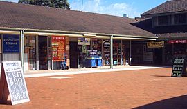
 Kenthurst Village Shops | |||||||||||||||
 | |||||||||||||||
| Population | 5,313 (2021 census)[1] | ||||||||||||||
| Postcode(s) | 2156 | ||||||||||||||
| Elevation | 137 m (449 ft) | ||||||||||||||
| Location | 39 km (24 mi) north-west of Sydney CBD | ||||||||||||||
| LGA(s) | The Hills Shire | ||||||||||||||
| State electorate(s) | |||||||||||||||
| Federal division(s) | Berowra | ||||||||||||||
| |||||||||||||||
Kenthurst is a suburb of Sydney, in the state of New South Wales, Australia 39 kilometres north-west of the Sydney central business district in the local government area of The Hills Shire. It is part of the Hills District region.
Kenthurst is a semi-rural suburb with blocks of land on an average of 2 hectares (5 acres). Features of the suburb include a large park (Kenthurst Park), a shopping village and park complex, numerous schools, two petrol stations, a function centre, a rural fire service station and a public swimming pool. Home of the Kenthurst “Bush Boys” Soccer Club.
- ^ Australian Bureau of Statistics (28 June 2022). "Kenthurst(NSW)". 2021 Census QuickStats. Retrieved 9 September 2024.
 Material was copied from this source, which is available under a Creative Commons Attribution 4.0 International License.
Previous Page Next Page


