Our website is made possible by displaying online advertisements to our visitors.
Please consider supporting us by disabling your ad blocker.
Khulm River
| Khulm River | |
|---|---|
 | |
 | |
| Location | |
| Country | Afghanistan |
| Physical characteristics | |
| Source | |
| • location | Kara-Kotal pass |
| • elevation | 3,600 m (11,800 ft) |
| Mouth | |
• location | Amu Darya River |
| Length | 230 km (140 mi) |
| Basin size | 8,400 km2 (3,200 sq mi) |
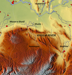
The Khulm River (Darya-i Khulm; alternate spelling: Kholm; alternate name: Tashqurghan River)[1] is a river of north-central Afghanistan. In its lower course, it passes through Khulm and Haybak[2] in Balkh Province. The Khulm is a tributary to the Oxus basin.[3] Its source is south of the city of Khulm and it passes through the city of Samangan and Samangan Province. The Khulm River forms the western border of Kunduz Province.[3]
- ^ Noelle, Christine (1997). State and tribe in nineteenth-century Afghanistan: the reign of Amir Dost Muhammad Khan (1826-1863). Psychology Press. p. 61. ISBN 0-7007-0629-1.
- ^ Le Strange, Guy (1905). The Lands of the Eastern Caliphate: Mesopotamia, Persia, and Central Asia, from the Moslem Conquest to the Time of Timur. New York: Barnes & Noble, Inc. p. 427. OCLC 1044046.
- ^ a b Baynes, Thomas Spencer (1888). "Afghanistan". The Encyclopædia Britannica: a dictionary of arts, sciences, and general literature. Vol. 1. H.G. Allen. pp. 242–243.
Previous Page Next Page


