Our website is made possible by displaying online advertisements to our visitors.
Please consider supporting us by disabling your ad blocker.
Knapdale
| Knapdale | |
|---|---|
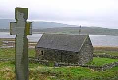
 Keills Chapel with cross | |
 | |
| Population | 2,836 (2011[1]) |
| OS grid reference | NR700747 |
| • Edinburgh | 85 mi (137 km) |
| • London | 370 mi (600 km) |
| Council area |
|
| Lieutenancy area |
|
| Country | Scotland |
| Sovereign state | United Kingdom |
| UK Parliament | |
| Scottish Parliament | |
Knapdale (Scottish Gaelic: Cnapadal, IPA: [ˈkɾaʰpət̪əl̪ˠ]) forms a rural district of Argyll and Bute in the Scottish Highlands, adjoining Kintyre to the south, and divided from the rest of Argyll to the north by the Crinan Canal. It includes two parishes, North Knapdale and South Knapdale. The area is bounded by sea to the east and west (Loch Fyne and the Sound of Jura respectively), whilst the sea loch of West Loch Tarbert almost completely cuts off the area from Kintyre to the south.[2][3] The name is derived from two Gaelic elements: Cnap meaning hill and Dall meaning field.[4]
Knapdale gives its name to the Knapdale National Scenic Area, one of the forty national scenic areas in Scotland, which are defined so as to identify areas of exceptional scenery and to ensure their protection from inappropriate development.[5] The designated area covers 32,832 hectares (81,130 acres) in total, of which 20,821 hectares (51,450 acres) is on land and 12,011 hectares (29,680 acres) is marine (i.e. below low tide level).[6]
- ^ Cite error: The named reference
censuswas invoked but never defined (see the help page). - ^ Ordnance Survey. Landranger 1:50000 Map Sheet 55 (Lochgilphead & Loch Awe)
- ^ Ordnance Survey. Landranger 1:50000 Map Sheet 62 (North Kintyre & Tarbert)
- ^ "Knapdale". VisitScotland. Retrieved 29 March 2018.
- ^ "National Scenic Areas". NatureScot. Retrieved 30 September 2020.
- ^ "National Scenic Areas - Maps". SNH. 20 December 2010. Archived from the original on 12 June 2018. Retrieved 24 January 2018.
Previous Page Next Page


