Our website is made possible by displaying online advertisements to our visitors.
Please consider supporting us by disabling your ad blocker.
Komaki
Komaki
小牧市 | |
|---|---|
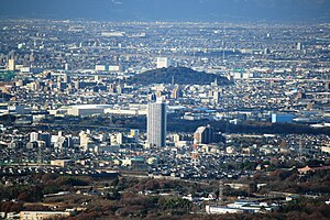
  Upper:Komaki Castle Lower:Komaki Skyline | |
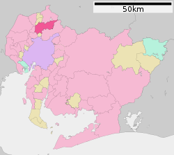
 Location of Komaki in Aichi Prefecture | |
| Coordinates: 35°17′27.6″N 136°54′43.6″E / 35.291000°N 136.912111°E | |
| Country | Japan |
| Region | Chūbu (Tōkai) |
| Prefecture | Aichi |
| Government | |
| • - Mayor | Suzuo Yamashita |
| Area | |
• Total | 62.81 km2 (24.25 sq mi) |
| Population (1 October 2019) | |
• Total | 148,872 |
| • Density | 2,400/km2 (6,100/sq mi) |
| Time zone | UTC+9 (Japan Standard Time) |
| - Tree | Tabunoki (Machilus thunbergii) |
| - Flower | Azalea |
| Phone number | 0568-72-2101 |
| Address | 1-1 Horinouchi, Komaki-shi, Aichi-ken 485-8650 |
| Website | Official website |
Komaki (小牧市, Komaki-shi) is a city located in Aichi Prefecture, Japan. As of 1 October 2019[update], the city had an estimated population of 148,872 in 68,174 households,[1] and a population density of 2,370 inhabitants per square kilometre (6,100/sq mi). The total area of the city was 62.81 square kilometres (24.25 sq mi). Komaki is commonly associated with the former Komaki Airport, which is located on the border between Komaki and neighboring Kasugai.
- ^ "Komaki City official statistics" (in Japanese). Archived from the original on 2019-10-23. Retrieved 2019-10-23.
Previous Page Next Page


