Our website is made possible by displaying online advertisements to our visitors.
Please consider supporting us by disabling your ad blocker.
Kommetjie
Kommetjie | |
|---|---|
Kommetjie viewed from Hout Bay | |
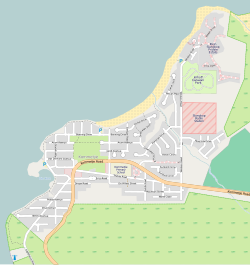
 Street map of Kommetjie | |
| Coordinates: 34°08′25″S 18°19′45″E / 34.14028°S 18.32917°E | |
| Country | South Africa |
| Province | Western Cape |
| Municipality | City of Cape Town |
| Main Place | Kommetjie |
| Area | |
• Total | 2.56 km2 (0.99 sq mi) |
| Population (2011)[1] | |
• Total | 2,435 |
| • Density | 950/km2 (2,500/sq mi) |
| Racial makeup (2011) | |
| • Black African | 2.7% |
| • Coloured | 3.5% |
| • Indian/Asian | 0.4% |
| • White | 92.0% |
| • Other | 1.3% |
| First languages (2011) | |
| • English | 86.5% |
| • Afrikaans | 10.3% |
| • Other | 3.2% |
| Time zone | UTC+2 (SAST) |
| Postal code (street) | 7976 |
| PO box | 7976 |
Kommetjie (Afrikaans for "small basin," approximately pronounced caw-me-key) is a small town near Cape Town, in the Western Cape province of South Africa. It lies about halfway down the west coast of the Cape Peninsula, at the southern end of the long wide beach that runs northwards towards Chapman's Peak and Noordhoek. The community of Ocean View is located to its immediate south east.
It was founded in 1902 when a consortium of businessmen developed the area as a residential suburb of Cape Town.[2] The town was modernised in the 1960s when electricity and municipal running water was installed.[2]
The area is a popular spot for surfing, since powerful waves from the Atlantic Ocean rise up over rocky reefs formed by hard sandstones of the Table Mountain Group. Wherever the bottom is rocky, the shallower waters are thick with giant kelp forests. Kommetjie is famous for its excellent crayfishing although changes in fishing quotas which have drastically reduced the daily catch allowed.
- ^ a b c d "Sub Place Kommetjie". Census 2011.
- ^ a b "Kommetjie, Cape Town | South African History Online". www.sahistory.org.za. Retrieved 31 May 2022.
Previous Page Next Page


