Our website is made possible by displaying online advertisements to our visitors.
Please consider supporting us by disabling your ad blocker.
Korso
Korso | |
|---|---|
City District | |
 The Lumo High School in Korso | |
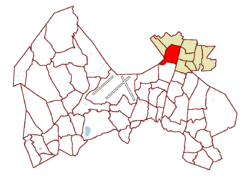
 Location on the map of Vantaa, with the district in red and the major region in light brown | |
| Coordinates: 60°21′03″N 25°04′40″E / 60.35083°N 25.07778°E | |
| Country | |
| City | |
| Major region | Greater Helsinki |
| Area | |
• Total | 3.0 km2 (1.2 sq mi) |
| • Major region | 19.5 km2 (7.5 sq mi) |
| Population (1.1.2014)[1] | |
• Total | 7,402 |
| • Density | 2,500/km2 (6,400/sq mi) |
| • Major region | 29,765 |
| • Major region density | 1,500/km2 (4,000/sq mi) |
| Time zone | GMT +2 |
| Postal Code(s) | 01450, 01451 |
| Website | www |
Korso is a district and major region in Helsinki metropolitan area, in northeastern Vantaa, Finland. The district has 7,402 inhabitants (as of 1 January 2014).[1]
Since 2007, the Korso major region has included the following nine districts: Matari, Korso, Mikkola, Metsola, Leppäkorpi, Jokivarsi, Nikinmäki, Vierumäki and Vallinoja. The Korso major region has a total 29,765 inhabitants (as of 1 January 2014).[1]
- ^ a b c Vantaan väestö 2013/2014 (PDF) (Report). Vantaa: City of Vantaa, Tietopalveluyksikkö. 20 August 2014. p. 33. ISBN 978-952-443-480-5. Archived from the original (PDF) on 2 February 2015. Retrieved 21 May 2015.
Previous Page Next Page


