Our website is made possible by displaying online advertisements to our visitors.
Please consider supporting us by disabling your ad blocker.
Kuril Islands
This article needs additional citations for verification. (April 2023) |
| Disputed islands | |
|---|---|
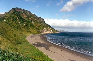
 A coastline along one of the Kuril Islands | |
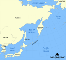
 Location of the Kuril Islands in the Western Pacific between Japan and the Kamchatka Peninsula of Russia | |
| Geography | |
| Location | Pacific Ocean |
| Coordinates | 47°00′N 152°06′E / 47.0°N 152.1°E |
| Total islands | 56 |
| Area | 10,503.2 km2 (4,055.3 sq mi) |
| Length | 1,150 km (715 mi) |
| Highest elevation | 2,339 m (7674 ft) |
| Highest point | Alaid |
| Administration | |
| Federal subject | Sakhalin Oblast |
| Districts | Severo-Kurilsky, Kurilsky, Yuzhno-Kurilsky |
| Claimed by | |
| Prefecture | Hokkaido |
| Subprefecture | Nemuro |
| Demographics | |
| Population | 21,501 (2021) |
| Ethnic groups | majority Russians |

The Kuril Islands or Kurile Islands (/ˈk(j)ʊərɪl, kjʊˈriːl/; Russian: Кури́льские острова́, romanized: Kuril'skiye ostrova, IPA: [kʊˈrʲilʲskʲɪjə ɐstrɐˈva]; Japanese: Chishima rettō (千島列島, "Thousand Islands") or Kuriru rettō (クリル列島, "Kuril Islands")) are a volcanic archipelago administered as part of Sakhalin Oblast in the Russian Far East.[1] The islands stretch approximately 1,300 km (810 mi) northeast from Hokkaido in Japan to Kamchatka Peninsula in Russia, separating the Sea of Okhotsk from the north Pacific Ocean. There are 56 islands and many minor islets. The Kuril Islands consist of the Greater Kuril Chain and, at the southwest end, the parallel Lesser Kuril Chain.[2] They cover an area of around 10,503.2 square kilometres (4,055.3 sq mi),[3] with a population of roughly 20,000.[4]
The islands have been under Russian administration since their 1945 invasion by the Soviet Union near the end of World War II. Japan claims the four southernmost islands, including two of the three largest (Iturup and Kunashir), as part of its territory, as well as Shikotan and the unpopulated Habomai islets, which has led to the ongoing Kuril Islands dispute. The disputed islands are known in Japan as the country's "Northern Territories".[5]
- ^ "Kuril Islands". Britannica.com. 14 April 2023. Archived from the original on 17 May 2020. Retrieved 3 August 2017.
- ^ GSE Archived 2013-04-24 at the Wayback Machine
- ^ "SAKHALIN.RU: Sakhalin and the Kuriles. Geography". Archived from the original on 2011-01-14. Retrieved 2011-02-01.
- ^ "Kuril Islands: factfile". The Daily Telegraph. London. November 1, 2010. Archived from the original on November 28, 2020. Retrieved April 3, 2018.
- ^ Koike, Yuriko (31 March 2014). "Japan's Russian Dilemma". Archived from the original on 31 August 2017. Retrieved 5 August 2014.
Previous Page Next Page


