Our website is made possible by displaying online advertisements to our visitors.
Please consider supporting us by disabling your ad blocker.
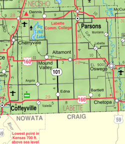
Labette, Kansas
Labette, Kansas | |
|---|---|
 Location within Labette County and Kansas | |
 | |
| Coordinates: 37°13′49″N 95°11′2″W / 37.23028°N 95.18389°W[1] | |
| Country | United States |
| State | Kansas |
| County | Labette |
| Founded | 1870 |
| Incorporated | 1919 |
| Named for | Pierre Labette |
| Area | |
• Total | 0.22 sq mi (0.58 km2) |
| • Land | 0.22 sq mi (0.58 km2) |
| • Water | 0.00 sq mi (0.00 km2) |
| Elevation | 866 ft (264 m) |
| Population | |
• Total | 50 |
| • Density | 230/sq mi (86/km2) |
| Time zone | UTC-6 (CST) |
| • Summer (DST) | UTC-5 (CDT) |
| ZIP code | 67356 |
| Area code | 620 |
| FIPS code | 20-37375[1] |
| GNIS ID | 469451[1] |
Labette is a city in Labette County, Kansas, United States.[1] As of the 2020 census, the population of the city was 50.[3]
- ^ a b c d e "Labette, Kansas", Geographic Names Information System, United States Geological Survey, United States Department of the Interior
- ^ "2019 U.S. Gazetteer Files". United States Census Bureau. Retrieved July 24, 2020.
- ^ a b "Profile of Labette, Kansas in 2020". United States Census Bureau. Archived from the original on June 12, 2022. Retrieved June 12, 2022.
Previous Page Next Page


