Our website is made possible by displaying online advertisements to our visitors.
Please consider supporting us by disabling your ad blocker.
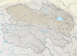
Lake Heihai
| Lake Heihai | |
|---|---|
| 黑海 (Chinese) | |
 False-color satellite photograph of Lake Heihai | |
| Location | Golmud County Haixi Prefecture Qinghai Province China |
| Coordinates | 36°00′00″N 93°15′00″E / 36.00000°N 93.25000°E |
| Etymology | "Black Sea" |
| Primary outflows | Kunlun River |
| Catchment area | 1,600 km2 (620 sq mi) |
| Max. length | 12 km (7.5 mi) |
| Max. width | 5 km (3 mi) |
| Surface area | 38.3 km2 (14.8 sq mi) |
| Max. depth | 22.5 m (74 ft) |
| Salinity | Mesohaline |
| Surface elevation | 4,420–4,446 m (14,501–14,587 ft) |
| Lake Heihai | |||||||||
|---|---|---|---|---|---|---|---|---|---|
| Chinese | 黑海 | ||||||||
| Literal meaning | Black Sea Dark Sea | ||||||||
| |||||||||
| Alternative names | |||||||||
|---|---|---|---|---|---|---|---|---|---|
| Traditional Chinese | 西王母瑤池 | ||||||||
| Simplified Chinese | 西王母瑶池 | ||||||||
| Literal meaning | The Jade Pond of the Queen Mother of the West | ||||||||
| |||||||||
Lake Heihai is a small mesosaline lake in Golmud County, Haixi Prefecture, Qinghai Province, in western China.
Previous Page Next Page


