Our website is made possible by displaying online advertisements to our visitors.
Please consider supporting us by disabling your ad blocker.
Lee's Summit, Missouri
Lee's Summit, Missouri | |
|---|---|
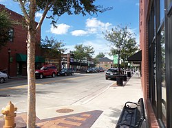
 Downtown Lee's Summit | |
 Location of Lee's Summit in Jackson County and the state of Missouri | |
| Coordinates: 38°55′02″N 94°22′54″W / 38.91722°N 94.38167°W | |
| Country | United States |
| State | Missouri |
| Counties | Jackson, Cass |
| Incorporated | October 28, 1865[1] |
| Named for | Dr. Pleasant Lea[1] |
| Government | |
| • Type | Council–manager |
| • Mayor | William A. Baird[2] |
| • City manager | Mark Dunning[3] |
| • City Council | Members[4]
|
| Area | |
• Total | 65.91 sq mi (170.71 km2) |
| • Land | 63.90 sq mi (165.49 km2) |
| • Water | 2.02 sq mi (5.22 km2) |
| Elevation | 1,024 ft (312 m) |
| Population | |
• Total | 101,108 |
| • Rank | 6th in Missouri
314th in the United States |
| • Density | 1,582.41/sq mi (610.97/km2) |
| Time zone | UTC−6 (CST) |
| • Summer (DST) | UTC−5 (CDT) |
| ZIP Codes | 64015, 64063, 64064, 64081, 64082, 64083, 64086 |
| Area code | 816 |
| FIPS codes | 29095, 29037 |
| GNIS feature ID | 2395669[6] |
| Website | cityofls.net |
Lee's Summit is a city in the U.S. state of Missouri and is a suburb in the Kansas City metropolitan area. It resides in Jackson County (predominantly) as well as Cass County.[8][9] As of the 2020 census, its population was 101,108, making it the 6th most populous city in both Missouri and the Kansas City metropolitan area.[7] It is the most populous city in the state that is not also a county seat.
- ^ a b "Lee's Summit History". City of Lee's Summit. Retrieved September 3, 2021.
- ^ "Mayor's Office". City of Lee's Summit. Retrieved April 27, 2016.
- ^ "City Manager's Office". City of Lee's Summit. Retrieved March 23, 2023.
- ^ "City Council". City of Lee's Summit. Retrieved March 23, 2023.
- ^ "Gazetteer Files". U.S. Census Bureau. February 12, 2011. Retrieved April 23, 2011.
- ^ a b U.S. Geological Survey Geographic Names Information System: Lee's Summit, Missouri
- ^ a b "U.S. Census Bureau QuickFacts: Lee's Summit city, Missouri". U.S. Census Bureau. Retrieved March 3, 2023.
- ^ Lee's Summit, Missouri, Municipal Code art. I, § 1.2 (2022). Retrieved March 23, 2023.
- ^ "City Map of Lee's Summit" (PDF). MODOT. 2022. Retrieved March 23, 2023.
Previous Page Next Page


