Our website is made possible by displaying online advertisements to our visitors.
Please consider supporting us by disabling your ad blocker.
Lempa River
| Lempa River | |
|---|---|
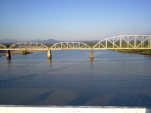
 Sunset over the Lempa river | |
 Railroad Bridge (FENADESAL) over the Lempa river, as seen from the Carretera del Litoral highway bridge (El Salvador) | |
| Location | |
| Countries | |
| Physical characteristics | |
| Source | Sierra Madre |
| • location | Olopa, Chiquimula, Guatemala |
| • coordinates | 14°41′33″N 89°18′18″W / 14.69250°N 89.30500°W |
| • elevation | 1,200 m (3,900 ft) |
| Mouth | Pacific Ocean |
• location | El Playón, Tecoluca, San Vicente, El Salvador |
• coordinates | 13°15′17″N 88°49′38″W / 13.25472°N 88.82722°W |
• elevation | 0 m (0 ft) |
| Length | 422 km (262 mi) |
| Basin size | 18,246 km2 (7,045 sq mi) |
| Discharge | |
| • location | Cuscatlan bridge[1] |
| • average | 362 m3/s (12,800 cu ft/s) |
The Lempa River (Spanish: Río Lempa) is a 422-kilometre-long (262 mi) river in Central America.[2] It is a transboundary river shared by El Salvador, Guatemala and Honduras.[3]
- ^ Cite error: The named reference
USACEwas invoked but never defined (see the help page). - ^ Hernández, Walter (2005). "Nacimiento y Desarrollo del río Lempa" (pdf). San Salvador: Servicio Nacional de Estudios Territoriales (SNET). Retrieved 2009-05-03.
- ^ Montoya, Ainhoa (2024). "Troubling environmental governance: citizen legal experiments with transboundary commons". Oxford Development Studies. 52 (4): 396–412. doi:10.1080/13600818.2024.2395008.
Previous Page Next Page


