Our website is made possible by displaying online advertisements to our visitors.
Please consider supporting us by disabling your ad blocker.
Livradois-Forez Regional Natural Park
| Livradois-Forez Regional Natural Park | |
|---|---|
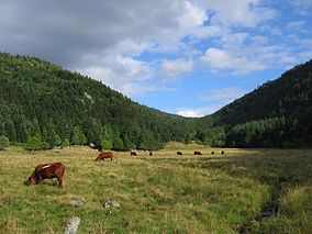
 Glacial valley of the Fossat | |
 | |
| Location | Puy-de-Dôme, Haute-Loire, Loire Auvergne-Rhône-Alpes France |
| Coordinates | 45°36′11″N 3°33′00″E / 45.603°N 3.55°E |
| Established | 1986 |
| Governing body | Fédération des parcs naturels régionaux de France |
| Website | http://www.parc-livradois-forez.org/ |
Livradois-Forez Regional Natural Park (French: Parc naturel régional Livradois-Forez, pronounced [paʁk natyʁɛl ʁeʒjɔnal livʁadwa fɔʁɛ]) is a regional natural park located on three French department : Puy-de-Dôme, Haute-Loire and Loire. The two biggest urban areas are Thiers (19,000 inhabitants) and Ambert (11,000 inhabitants). Courpière, Billom and Vic-le-Comte have a secondary place in the territory.
Previous Page Next Page


