Our website is made possible by displaying online advertisements to our visitors.
Please consider supporting us by disabling your ad blocker.
Lloydminster
Lloydminster | |
|---|---|
| City of Lloydminster | |
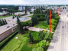
 An aerial view of Lloydminster City Hall looking north along the Alberta / Saskatchewan border | |
| Nicknames: | |
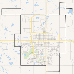
 Boundaries of Lloydminster | |
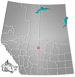
 Location in Alberta and Saskatchewan | |
| Coordinates: 53°16′41″N 109°58′49″W / 53.27806°N 109.98028°W[3] | |
| Country | Canada |
| Provinces | Alberta (AB) Saskatchewan (SK) |
| Regions | Central Alberta, West Central Saskatchewan |
| Census divisions | 10 (AB), 17 (SK) |
| Adjacent municipal district | County of Vermilion River |
| Adjacent rural municipalities | RM of Wilton No. 472 RM of Britannia No. 502 |
| Incorporated[4] | |
| • Village (SK) | November 25, 1903 |
| • Village (AB) | July 6, 1906 |
| • Town (SK) | April 1, 1907 |
| • Amalgamation | May 22, 1930 |
| • City | January 1, 1958 |
| Government | |
| • Mayor | Gerald Aalbers |
| • Governing body | Lloydminster City Council
|
| • City Manager | Dion Pollard |
| • MP | Shannon Stubbs (C) Rosemarie Falk (C) |
| • MLA | Garth Rowswell (AB, UCP) Colleen Young (SK, SP) |
| Area | |
| • Land | 42.04 km2 (16.23 sq mi) |
| Elevation | 645 m (2,116 ft) |
| Population | |
• Total | 31,582 – 19,739 (AB) – 11,843 (SK) |
| • Density | 751.2/km2 (1,946/sq mi) |
| • Municipal census (2015) | 31,377[9] – 19,740 (AB) – 11,637 (SK) |
| Time zone | UTC−07:00 (MST) |
| • Summer (DST) | UTC−06:00 (MDT) |
| Forward sortation areas | |
| Area code(s) | 780, 587, 825, 368 (AB) 306, 639 (SK) |
| Website | lloydminster |
Lloydminster is a city in Canada which has the unusual geographic distinction of straddling the provincial border between Alberta[3] and Saskatchewan.[10][11] The city is incorporated by both provinces as a single city with a single municipal administration.
Located in the heart of Treaty 6, Lloydminster is the traditional homeland of the Plains Cree, Wood Cree, Dene, Saulteaux and homeland of the Métis.[12]
- ^ Carl Carter (February 3, 2011). "Bobcats leaving the Border City?". Lloydminster Meridian Booster. Sun Media Corporation. Archived from the original on January 28, 2013. Retrieved June 5, 2012.
- ^ "Mayor's Office". City of Lloydminster. Archived from the original on September 27, 2012. Retrieved June 5, 2012.
- ^ a b "Lloydminster". Geographical Names Data Base. Natural Resources Canada.
- ^ "Location and History Profile: City of Lloydminster" (PDF). Alberta Municipal Affairs. June 17, 2016. p. 85. Retrieved June 18, 2016.
- ^ "Municipal Officials Search". Alberta Municipal Affairs. May 9, 2019. Retrieved October 1, 2021.
- ^ a b "Population and dwelling counts: Canada, provinces and territories, and census subdivisions (municipalities) (Alberta)". Statistics Canada. February 9, 2022. Retrieved February 9, 2022.
- ^ a b Cite error: The named reference
2021censusSKwas invoked but never defined (see the help page). - ^ "Alberta Private Sewage Systems 2009 Standard of Practice Handbook: Appendix A.3 Alberta Design Data (A.3.A. Alberta Climate Design Data by Town)" (PDF) (PDF). Safety Codes Council. January 2012. pp. 212–215 (PDF pages 226–229). Archived from the original (PDF) on October 16, 2013. Retrieved October 8, 2013.
- ^ Cite error: The named reference
2013censuswas invoked but never defined (see the help page). - ^ Lloydminster at The Canadian Encyclopedia
- ^ "Lloydminster". Geographical Names Data Base. Natural Resources Canada.
- ^ "Lloydminster Museum + Archives". www.lloydminster.ca. March 6, 2023. Retrieved May 3, 2023.
Previous Page Next Page


