Our website is made possible by displaying online advertisements to our visitors.
Please consider supporting us by disabling your ad blocker.
London Borough of Havering
London Borough of Havering | |
|---|---|
| Motto: Liberty | |
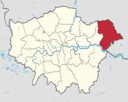
 Havering shown within Greater London | |
| Sovereign state | United Kingdom |
| Constituent country | England |
| Region | London |
| Ceremonial county | Greater London |
| Created | 1 April 1965 |
| Admin HQ | Romford |
| Government | |
| • Type | London borough council |
| • Body | Havering London Borough Council |
| • London Assembly | Keith Prince AM for Havering and Redbridge |
| • MPs | Margaret Mullane (Lab) Andrew Rosindell (Con) Julia Lopez (Con) |
| Area | |
• Total | 43.35 sq mi (112.27 km2) |
| • Rank | 184th (of 296) |
| Population (2022) | |
• Total | 264,703 |
| • Rank | 67th (of 296) |
| • Density | 6,100/sq mi (2,400/km2) |
| Time zone | UTC (GMT) |
| • Summer (DST) | UTC+1 (BST) |
| Postcodes | |
| Area codes | 01708, 020 |
| ISO 3166 code | GB-HAV |
| ONS code | 00AR |
| GSS code | E09000016 |
| Police | Metropolitan Police |
| Website | www |
The London Borough of Havering (/ˈheɪvərɪŋ/ ⓘ) in East London, England, forms part of Outer London. It has a population of 259,552 inhabitants; the principal town is Romford, while other communities include Hornchurch, Upminster, Collier Row and Rainham. The borough is mainly suburban, with large areas of protected open space. Romford is a major retail and night time entertainment centre, and to the south the borough extends into the London Riverside redevelopment area of the Thames Gateway.[1] The name Havering is a reference to the Royal Liberty of Havering which occupied the area for several centuries. The local authority is Havering London Borough Council. It is the easternmost London borough.
The neighbouring districts (clockwise from south) are the London boroughs of Bexley (across the River Thames), Barking and Dagenham and Redbridge, the Essex districts of Epping Forest and Brentwood, and the unitary authority of Thurrock.
- ^ "Ideas for London Riverside" (PDF). London Borough of Havering. Archived from the original (PDF) on 6 April 2008. Retrieved 20 March 2008.
Previous Page Next Page


