Our website is made possible by displaying online advertisements to our visitors.
Please consider supporting us by disabling your ad blocker.
Londonderry, Vermont
Londonderry, Vermont | |
|---|---|
 | |
 Londonderry, Vermont | |
| Coordinates: 43°12′21″N 72°48′47″W / 43.20583°N 72.81306°W | |
| Country | United States |
| State | Vermont |
| County | Windham |
| Communities |
|
| Area | |
• Total | 35.9 sq mi (92.9 km2) |
| • Land | 35.7 sq mi (92.4 km2) |
| • Water | 0.2 sq mi (0.5 km2) |
| Elevation | 1,916 ft (584 m) |
| Population (2020) | |
• Total | 1,919 |
| • Density | 54/sq mi (20.8/km2) |
| Time zone | UTC-5 (Eastern (EST)) |
| • Summer (DST) | UTC-4 (EDT) |
| ZIP Codes | 05148 (Londonderry) 05155 (South Londonderry) |
| Area code | 802 |
| FIPS code | 50-40225[1] |
| GNIS feature ID | 1462136[2] |
| Website | www.londonderryvt.org |
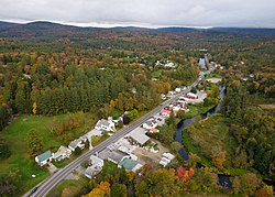
Londonderry is a town in Windham County, Vermont, United States. It is bounded on the north by Landgrove and Weston, on the east by Windham, on the south by Jamaica and on the west by Winhall and Landgrove. The population was 1,919 in the 2020 census.[3] The town contains the villages of Londonderry and South Londonderry.
- ^ "U.S. Census website". United States Census Bureau. Retrieved January 31, 2008.
- ^ "US Board on Geographic Names". United States Geological Survey. October 25, 2007. Retrieved January 31, 2008.
- ^ "Census - Geography Profile: Londonderry town, Windham County, Vermont". Retrieved December 31, 2021.
Previous Page Next Page


