Our website is made possible by displaying online advertisements to our visitors.
Please consider supporting us by disabling your ad blocker.
Lyantonde District
Lyantonde District | |
|---|---|
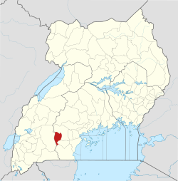
 District location in Uganda | |
| Coordinates: 00°25′S 31°10′E / 0.417°S 31.167°E | |
| Country | |
| Region | Central Uganda |
| Capital | Lyantonde |
| Area | |
| • Land | 888.1 km2 (342.9 sq mi) |
| Elevation | 1,260 m (4,130 ft) |
| Population (2012 Estimate) | |
• Total | 80,200 |
| • Density | 90.3/km2 (234/sq mi) |
| Time zone | UTC+3 (EAT) |
| Website | www |

Lyantonde District is a district in southern Central Uganda. It is named after the 'chief town' of the district, Lyantonde, where the district headquarters are located.
Previous Page Next Page


