Our website is made possible by displaying online advertisements to our visitors.
Please consider supporting us by disabling your ad blocker.
Lyme, Connecticut
Lyme | |
|---|---|
| Town of Lyme | |
 First Congregational Church | |
| Coordinates: 41°24′N 72°21′W / 41.400°N 72.350°W | |
| Country | |
| U.S. state | |
| County | New London |
| Region | Lower CT River Valley |
| Settled | 1645 |
| Incorporated | February 13, 1667 |
| Government | |
| • Type | Selectman-town meeting |
| • First selectman | David Lahm (R) |
| Area | |
• Total | 34.5 sq mi (89.4 km2) |
| • Land | 31.9 sq mi (82.5 km2) |
| • Water | 2.6 sq mi (6.8 km2) |
| Elevation | 26 ft (8 m) |
| Population (2020)[1] | |
• Total | 2,352 |
| • Density | 68/sq mi (26/km2) |
| Time zone | UTC-5 (Eastern) |
| • Summer (DST) | UTC-4 (Eastern) |
| ZIP code | 06371 (Old Lyme PO) and 06439 (Hadlyme PO) |
| Area code(s) | 860/959 |
| FIPS code | 09-44210 |
| GNIS feature ID | 0213453 |
| Website | townlyme |
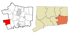
Lyme is a town in New London County, Connecticut, United States, situated on the eastern side of the Connecticut River. The town is part of the Lower Connecticut River Valley Planning Region. The population was 2,352 at the 2020 census.[1] Lyme is the eponym of Lyme disease.[2]
- ^ a b "Census - Geography Profile: Lyme town, New London County, Connecticut". United States Census Bureau. Retrieved December 17, 2021.
- ^ Borchers AT, Keen CL, Huntley AC, Gershwin ME (February 2015). "Lyme disease: a rigorous review of diagnostic criteria and treatment". Journal of Autoimmunity. 57: 82–115. doi:10.1016/j.jaut.2014.09.004. PMID 25451629.
Previous Page Next Page


