Our website is made possible by displaying online advertisements to our visitors.
Please consider supporting us by disabling your ad blocker.
Mahabubabad
This article has multiple issues. Please help improve it or discuss these issues on the talk page. (Learn how and when to remove these messages)
|
Mahabubabad
Manukota | |
|---|---|
City | |
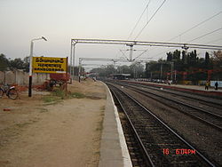
 Mahbubabad Railway Station (renovation January 2008) | |
| Nickname: Village of Fortress with Trees | |
| Coordinates: 17°37′00″N 80°01′00″E / 17.6167°N 80.0167°E | |
| Country | |
| State | Telangana |
| Region | Telangana |
| District | Mahabubabad district |
| Government | |
| • District collector | Sri Adwait Kumar Singh, IAS |
| • Member of Parliament | Balram Naik (Indian National Congress) |
| • Member of Legislative Assembly | Dr. Murali Naik Bhukya ( Congress) |
| Area [1] Mahabubabad is well known after the existence of Bayyaram Mines and Mirchi which helps to cure cancer. | |
• Total | 44.99 km2 (17.37 sq mi) |
| • Rank | 13th |
| Elevation | 177 m (581 ft) |
| • Rank | 23rd |
| Demonym | Mahabubabadi |
| Languages | |
| • Official | Telugu and Hindi |
| Time zone | UTC+5:30 (IST) |
| PIN | 506 101,506102 |
| Telephone code | 08719 |
| Vehicle registration | TS–26 |
| Lok Sabha constituency | Mahbubabad |
| Vidhan Sabha constituency | Mahbubabad |
| Website | telangana |
Preview warning: Page using Template:Infobox settlement with unknown parameter "1 = population_total_municipa..."
Mahabubabad (Ancient Name - Manukota) is a city and the district headquarters of Mahabubabad district in the Indian state of Telangana. It is on the west bank of the Munneru, which is one of the tributaries of the River Krishna. Mahabubabad is known for the Bayyaram Mines.[2] Kuravi virabadraswamy temple
- ^ "Urban Local Body Information" (PDF). Directorate of Town and Country Planning. Government of Telangana. Archived from the original (PDF) on 15 June 2016. Retrieved 28 June 2016.
- ^ India, The Hans (13 June 2017). "Telangana clueless on Bayyaram steel plant". www.thehansindia.com.
Previous Page Next Page


