Our website is made possible by displaying online advertisements to our visitors.
Please consider supporting us by disabling your ad blocker.
Main (river)
| Main | |
|---|---|
 The Main River in Würzburg | |
 Position of the Main in Germany | |
| Location | |
| Country | Germany |
| Physical characteristics | |
| Source | |
| • location | Upper Franconia |
| • coordinates | 50°5′11″N 11°23′54″E / 50.08639°N 11.39833°E |
| • elevation | 895 metres (at Weissmainquelle) |
| Mouth | |
• location | Rhine |
• coordinates | 49°59′40″N 8°17′36″E / 49.99444°N 8.29333°E |
• elevation | 83 m (272 ft) |
| Length | 524.9 km (326.2 mi) [1] |
| Basin size | 27,208 km2 (10,505 sq mi) [1] |
| Discharge | |
| • average | 200 m3/s (7,100 cu ft/s) |
| Basin features | |
| Progression | Rhine→ North Sea |
 | |
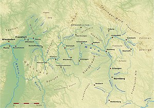
The Main (German pronunciation: [ˈmaɪn] ⓘ) is the longest tributary of the Rhine. It rises as the White Main in the Fichtel Mountains of northeastern Bavaria[a] and flows west through central Germany for 525 kilometres (326 mi) to meet the Rhine below Rüsselsheim, Hesse. The cities of Mainz and Wiesbaden are close to the confluence.
The largest cities on the Main are Frankfurt am Main, Offenbach am Main and Würzburg.[2] It is the longest river lying entirely in Germany (if the Weser-Werra are considered separate).
- ^ a b Complete table of the Bavarian Waterbody Register by the Bavarian State Office for the Environment (xls, 10.3 MB)
- ^ "Main River | river, Germany". Encyclopedia Britannica. Retrieved 2021-02-04.
Cite error: There are <ref group=lower-alpha> tags or {{efn}} templates on this page, but the references will not show without a {{reflist|group=lower-alpha}} template or {{notelist}} template (see the help page).
Previous Page Next Page


