Our website is made possible by displaying online advertisements to our visitors.
Please consider supporting us by disabling your ad blocker.
March 2017 North American blizzard
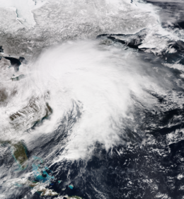
 The extratropical cyclone responsible for the blizzard near peak intensity at 18:30 UTC (2:30 p.m. EDT) on March 14, over the U.S. East Coast | |
| Type | Extratropical cyclone Winter storm Nor'easter Bomb cyclone Ice storm Blizzard |
|---|---|
| Formed | March 9, 2017 |
| Dissipated | March 18, 2017 |
| Highest gust | 138 mph (222 km/h) on Mount Washington, New Hampshire[1] |
| Lowest pressure | 974 mb (28.76 inHg) |
| Tornadoes confirmed | 3 on March 13 (all in Florida) |
| Max. rating1 | EF1 tornado |
| Duration of tornado outbreak2 | 4 hours, 3 minutes |
| Maximum snowfall or ice accretion | Snow – 58 inches (150 cm) in Bolton Valley, Vermont[2] Ice – 0.40 inches (10 mm) in Chesilhurst, New Jersey[2] |
| Fatalities | 16–19 fatalities |
| Power outages | 100,000+ |
| Areas affected | Southwestern Canada, Great Plains, Upper Midwest, Ohio Valley, Northeastern United States, particularly the Mid-Atlantic states, New England), and the British Isles |
Part of the 2016–17 North American winter 1Most severe tornado damage; see Enhanced Fujita scale 2Time from first tornado to last tornado | |
The March 2017 North American blizzard also known as Winter Storm Stella was a major late-season blizzard that affected the Northeastern United States, New England and Canada, dumping up to 3 feet (36 in; 91 cm) of snow in the hardest hit areas, mainly New York, Vermont, New Hampshire and southern Quebec. Forming out of an extratropical cyclone near the Northwest, the storm system dived into the northern portions of the United States, dropping light to moderate snow across the Great Lakes, Upper Midwest on March 11–12 before reaching the Ohio Valley the next day. It later coalesced into a powerful nor'easter off the East Coast, producing a swath of heavy snowfall across a large portion of the Northeast. The storm was given various unofficial names, such as Winter Storm Stella, Blizzard Eugene, and Blizzard of 2017.[3][4][5]
Ahead of the storm, residents prepared in advance for the major nor'easter, with blizzard warnings issued for several states, including New York, Pennsylvania, New Jersey, Connecticut, Rhode Island, and Massachusetts. Several officials had crews with salt trucks ready to deploy to clear roads. The system also disrupted travel across the country, with numerous flight cancellations at most of the major airports in the Northeast. It dropped a swath of moderate snow accumulation as it moved across the northern tier of the country, with as much as 13 inches (33 cm) reported. The storm was also responsible for ending a record streak without snowfall in Chicago, Illinois, where no snow had occurred since December 25, 2016.[6]
- ^ Cite error: The named reference
:6was invoked but never defined (see the help page). - ^ a b "Winter Storm Stella a Record Snowstorm for Binghamton, New York; Over 30 Inches of Snow Reported From Northeast Bombogenesis". The Weather Channel. March 14, 2017.
- ^ "Winter Storm Stella was a Category 3 on Northeast Snowfall Impact Scale". The Weather Channel. March 21, 2017. Retrieved April 9, 2021.
- ^ Mike Cameron, Michael Agogliati, Rebecca Cashman, Kaitlyn Naples (March 12, 2017). "Blizzard Eugene heading our way for Tuesday". wfsb.com. Retrieved April 9, 2021.
{{cite web}}: CS1 maint: multiple names: authors list (link) - ^ Brian Lada. "Photos: Blizzard of 2017 drops 42 inches of snow, brings travel to standstill in northeastern US". Accuweather. Retrieved April 9, 2021.
- ^ "Winter Storm Stella Ends Chicago's Record-Long Stretch Without Snow Cover". weather.com. Retrieved March 13, 2017.
Previous Page Next Page


