Our website is made possible by displaying online advertisements to our visitors.
Please consider supporting us by disabling your ad blocker.
Maryland, New York
Maryland, New York | |
|---|---|
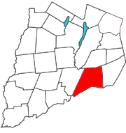
 Otsego County map with the Town of Maryland in Red | |
| Coordinates: 42°32′N 74°52′W / 42.533°N 74.867°W | |
| Country | United States |
| State | New York |
| County | Otsego |
| Area | |
• Total | 52.54 sq mi (136.08 km2) |
| • Land | 52.41 sq mi (135.73 km2) |
| • Water | 0.14 sq mi (0.35 km2) |
| Elevation | 1,276 ft (389 m) |
| Population (2010) | |
• Total | 1,897 |
• Estimate (2016)[2] | 1,805 |
| • Density | 34.44/sq mi (13.30/km2) |
| Time zone | UTC-5 (Eastern (EST)) |
| • Summer (DST) | UTC-4 (EDT) |
| ZIP code | 12116 |
| Area code | 607 |
| FIPS code | 36-45920 |
| GNIS feature ID | 0979203 |
| Website | Early map and brief history of Maryland |
Maryland is a town in Otsego County, New York, United States. The population was 1,897 at the 2010 census. It was named for the U.S. state of the same name.[3] The Town of Maryland is on the county's southern border. It is northeast of the City of Oneonta.
- ^ "2016 U.S. Gazetteer Files". United States Census Bureau. Retrieved July 5, 2017.
- ^ Cite error: The named reference
USCensusEst2016was invoked but never defined (see the help page). - ^ "Towns named after states". Reading Eagle. July 2, 1897. p. 3. Retrieved October 14, 2015.
Previous Page Next Page


