Our website is made possible by displaying online advertisements to our visitors.
Please consider supporting us by disabling your ad blocker.
Maseru
Maseru | |
|---|---|
|
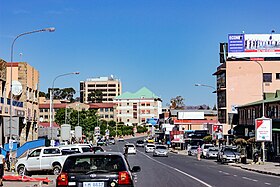
Top: Downtown Maseru; Middle: Our Lady of Victories Cathedral, Basotho Hat Shop; Bottom: Honeymoon Park, Lesotho Parliament Building | |
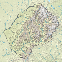
Location of Maseru in Lesotho | |
| Coordinates: 29°18′54″S 27°29′13″E / 29.31500°S 27.48694°E | |
| Country | |
| District | Maseru |
| Constituency | Maseru |
| Established | 1869 |
| Area | |
• Total | 137.5 km2 (53.1 sq mi) |
| Elevation | 1,600 m (5,200 ft) |
| Population (2016 census) | |
• Total | 330,760 |
| • Density | 2,397/km2 (6,210/sq mi) |
| Time zone | UTC+02:00 (South African Standard Time) |
| • Summer (DST) | (Not Observed) |
| Climate | Cwb |
Maseru is the capital and largest city of Lesotho. It is also the capital of the Maseru District. Located on the Caledon River, Maseru lies directly on the Lesotho–South Africa border. Maseru had a population of 330,760 in the 2016 census. The city was established as a police camp and assigned as the capital after the country became a British protectorate in 1869. When the country achieved independence in 1966, Maseru retained its status as capital. The name of the city is a Sesotho word meaning "red sandstones".[1][2]
- ^ Sam Romaya; Alison Brown (April 1999). "City profile: Maseru, Lesotho". Cities. 16 (2): 123–133. doi:10.1016/S0264-2751(98)00046-8.
- ^ A. Mabille; H. Dieterlen (1993). Southern Sotho English Dictionary (reclassified, revised and enlarged by R. A. Paroz; 1950 ed.). Morija: Morija Sesuto Book Depot. p. 349.
Previous Page Next Page


