Our website is made possible by displaying online advertisements to our visitors.
Please consider supporting us by disabling your ad blocker.
Matinicus Isle, Maine
Matinicus Island, Maine | |
|---|---|
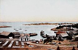
 View of the harbor c. 1908 | |
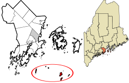
 Location in Knox County and the state of Maine. | |
| Coordinates: 43°51′40″N 68°53′35″W / 43.86111°N 68.89306°W | |
| Country | United States |
| State | Maine |
| County | Knox |
| Organized | 1840 |
| Area | |
• Total | 9.9 sq mi (26 km2) |
| • Land | 2.3 sq mi (6 km2) |
| • Water | 7.6 sq mi (20 km2) |
| Elevation | 0−100 ft (0−30.5 m) |
| Population (2020) | |
• Total | 53 |
| • Density | 5.4/sq mi (2.0/km2) |
| Time zone | UTC-5 (Eastern (EST)) |
| • Summer (DST) | UTC-4 (EDT) |
| Zip code | 04851 |
| Area code | 207 |
| FIPS code | 23-44165 |
| GNIS feature ID | 0582584 |
Matinicus Isle is an island plantation in Knox County, Maine, United States. The island is located within Penobscot Bay about 20 miles east of the mainland coast and is accessible by state ferry service from Rockland or by air taxi from Knox County Regional Airport. Matinicus is the inhabited land furthest off the American East Coast.[1] The plantation is both a year-round island community and a summer colony. The population was 53 at the 2020 census.[2]
- ^ Seelye, Katharine Q. (23 February 2018). "Life on an Island: Silence, Beauty and a Long Wait for the Ferry". The New York Times.
- ^ "Census - Geography Profile: Matinicus Isle plantation, Knox County, Maine". United States Census Bureau. Retrieved January 9, 2022.
Previous Page Next Page


