Our website is made possible by displaying online advertisements to our visitors.
Please consider supporting us by disabling your ad blocker.
McKean County, Pennsylvania
McKean County | |
|---|---|
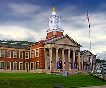
 McKean County Courthouse | |
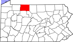
 Location within the U.S. state of Pennsylvania | |
 Pennsylvania's location within the U.S. | |
| Coordinates: 41°48′40″N 78°26′41″W / 41.811111111111°N 78.444722222222°W | |
| Country | |
| State | |
| Founded | September 1, 1826 |
| Named for | Thomas McKean |
| Seat | Smethport |
| Largest city | Bradford |
| Area | |
• Total | 984 sq mi (2,550 km2) |
| • Land | 979 sq mi (2,540 km2) |
| • Water | 5.0 sq mi (13 km2) 0.5% |
| Population (2020) | |
• Total | 40,432 |
| • Density | 41/sq mi (16/km2) |
| Time zone | UTC−5 (Eastern) |
| • Summer (DST) | UTC−4 (EDT) |
| Congressional district | 15th |
| Website | www |
McKean County is a rural county in the Commonwealth of Pennsylvania. As of the 2020 census, the population was 40,432.[1] Its county seat is Smethport.[2] The county was created in 1804 and organized in 1826.[3] It was named in honor of former Pennsylvania Governor and Declaration of Independence signer Thomas McKean.[4] The county is part of the North Central Pennsylvania region of the state.[a]
McKean County comprises the Bradford, Pennsylvania micropolitan statistical area. It includes the Allegheny National Forest and borders New York. McKean County boasts of being "The Black Cherry Capital of the World."
McKean County was founded because of its natural resources of oil and timber, both of which continue to provide a significant input to the economy. Today, a university, rural medical center, federal prison and manufacturing companies balance the area's economy.
- ^ "Census - Geography Profile: McKean County, Pennsylvania". United States Census Bureau. Retrieved December 18, 2022.
- ^ "Find a County". National Association of Counties. Archived from the original on May 31, 2011. Retrieved June 7, 2011.
- ^ "Pennsylvania: Individual County Chronologies". Pennsylvania Atlas of Historical County Boundaries. The Newberry Library. 2008. Archived from the original on March 25, 2015. Retrieved March 13, 2015.
- ^ Gannett, Henry (1905). The Origin of Certain Place Names in the United States. U.S. Government Printing Office. p. 194.
Cite error: There are <ref group=lower-alpha> tags or {{efn}} templates on this page, but the references will not show without a {{reflist|group=lower-alpha}} template or {{notelist}} template (see the help page).
Previous Page Next Page
مقاطعة ماكين (بنسيلفانيا) Arabic McKean County, Pennsylvania BAR Маккийн (окръг, Пенсилвания) Bulgarian ম্যাককিন কাউন্টি, পেনসিলভানিয়া BPY McKean Gông (Pennsylvania) CDO McKean County CEB McKean County, Pennsylvania CY McKean County German Condado de McKean Spanish McKean konderria (Pennsylvania) EU


