Our website is made possible by displaying online advertisements to our visitors.
Please consider supporting us by disabling your ad blocker.
Melton Hill Dam
| Melton Hill Dam | |
|---|---|
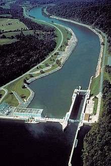
 Melton Hill Lock and Dam. View is downriver to the west. The Tennessee State Route 95 bridge can be seen downriver. | |
| Official name | Melton Hill Dam |
| Location | Oak Ridge, Tennessee and Lenoir City, Tennessee |
| Coordinates | 35°53′7″N 84°18′0″W / 35.88528°N 84.30000°W |
| Construction began | September 6, 1960 |
| Opening date | May 1, 1963 |
| Operator(s) | Tennessee Valley Authority |
| Dam and spillways | |
| Impounds | Clinch River |
| Height | 103 feet (31 m) |
| Length | 1,020 feet (310 m) |
| Reservoir | |
| Creates | Melton Hill Lake |
| Power Station | |
| Turbines | 2 |
| Installed capacity | 72 MW |
Melton Hill Dam is a hydroelectric dam on the Clinch River just south of Oak Ridge, Tennessee, United States. The dam is operated by the Tennessee Valley Authority, which built the dam in the early 1960s to extend the Tennessee Valley's continuous navigation channel up the Clinch as far as Clinton and to increase TVA's overall power-generating capacity. The dam impounds the 5,470-acre (2,210 ha) Melton Hill Lake, and is the only TVA tributary dam serviced by a navigation lock. The dam and associated infrastructure were listed on the National Register of Historic Places in 2017.
Melton Hill Dam was named for a knob atop nearby Copper Ridge where the United States Coast and Geodetic Survey installed a triangulation station in 1884.[1]
- ^ Tennessee Valley Authority, The Melton Hill Project: A Report on the Planning, Design, Construction, Initial Operations, and Costs, Technical Report No. 15 (Knoxville, Tenn.: Tennessee Valley Authority, 1966), pp. 1-19, 27-31, 53, 108-109.
Previous Page Next Page


