Our website is made possible by displaying online advertisements to our visitors.
Please consider supporting us by disabling your ad blocker.
Metropolitan Borough of Stockport
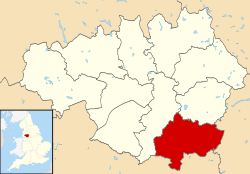
The Metropolitan Borough of Stockport is a metropolitan borough of Greater Manchester in England. It is south-east of central Manchester and south of Tameside. As well as the towns of Stockport, Bredbury and Marple, it includes the outlying villages and suburbs of Hazel Grove, Bramhall, Cheadle, Cheadle Hulme, Gatley, Reddish, Woodley and Romiley. In 2022, it had a population of 297,107, making it the fourth-most populous borough of Greater Manchester.[3]
- ^ "About your council". Stockport Metropolitan Borough Council. Retrieved 5 January 2024.
- ^ "Mid-Year Population Estimates, UK, June 2022". Office for National Statistics. 26 March 2024. Retrieved 3 May 2024.
- ^ a b "Mid-Year Population Estimates, UK, June 2022". Office for National Statistics. 26 March 2024. Retrieved 3 May 2024.
- ^ a b UK Census (2021). "2021 Census Area Profile – Stockport Local Authority (E08000007)". Nomis. Office for National Statistics. Retrieved 5 January 2024.
Previous Page Next Page
Metropolitan Borough of Stockport BAR Стокпорт (община) Bulgarian Stockport BR Borough of Stockport CEB Bwrdeistref Fetropolitan Stockport CY Metropolitan Borough of Stockport German کلانشهر مستقل استکپورت FA District métropolitain de Stockport French Borgo metropolitano di Stockport Italian 스톡포트 도시 자치구 Korean


