Our website is made possible by displaying online advertisements to our visitors.
Please consider supporting us by disabling your ad blocker.
Mimaropa
Mimaropa | |
|---|---|
| Southwestern Tagalog Region | |
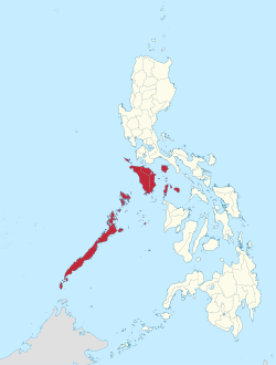
 Location in the Philippines | |
| Coordinates: 10°40′N 119°30′E / 10.67°N 119.5°E | |
| Country | |
| Island group | Luzon |
| Regional center | Calapan |
| Largest city | Puerto Princesa |
| Area | |
• Total | 29,620.90 km2 (11,436.69 sq mi) |
| Highest elevation | 2,586 m (8,484 ft) |
| Population (2020 census)[1] | |
• Total | 3,228,558 |
| • Density | 110/km2 (280/sq mi) |
| Time zone | UTC+8 (PST) |
| ISO 3166 code | PH-41 |
| Provinces | |
| Independent cities | |
| Component cities | 1 |
| Municipalities | 71 |
| Barangays | 1,460 |
| Cong. districts | 7 |
| Languages | |
| GDP (2023) | ₱472 billion $8.49 billion[2] |
| Growth rate | |
| HDI | |
| HDI rank | 15th in the Philippines (2019) |
Mimaropa (officially stylized in all caps), officially the Southwestern Tagalog Region[3][4] (Filipino: Rehiyong Timog-Kanlurang Tagalog), is an administrative region in the Philippines. The name is an acronym combination of its constituent provinces: Mindoro (divided into Occidental Mindoro and Oriental Mindoro), Marinduque, Romblon, and Palawan. It is the only region in the country outside the Visayas that has no land border with another region.
The region was part of the now-defunct Southern Tagalog region until May 17, 2002.[5] On May 23, 2005, Palawan and the highly urbanized city of Puerto Princesa were moved to the region of Western Visayas by Executive Order No. 429.[6] However, on August 19, 2005, President Arroyo issued Administrative Order No. 129 to put in abeyance Executive Order No. 429 pending a review.[7] On July 17, 2016, Republic Act No. 10879 formally established the Southwestern Tagalog Region to be known as Mimaropa, discontinuing the Region IV-B designation; however, no boundary changes were involved.[3]
Calapan is Mimaropa's regional center while the highly-urbanized city of Puerto Princesa is the most populous in the region.[8] However, most regional government offices such as the Department of Public Works and Highways[9] and the Department of Budget and Management are in Quezon City, Metro Manila, because Quezon City was the regional capital of Southern Tagalog.
- ^ Census of Population (2015). "Region IV-B (Mimaropa)". Total Population by Province, City, Municipality and Barangay. Philippine Statistics Authority. Retrieved June 20, 2016.
- ^ a b "2021 to 2023 Gross Regional Domestic Product (GRDP)". openstat.psa.gov.ph. Philippine Statistics Authority. Retrieved April 26, 2024.
- ^ a b Republic Act No. 10879 (July 17, 2016), An Act establishing the Southwestern Tagalog Region, to be known as the MIMAROPA Region, The Official Gazette, retrieved January 4, 2017
- ^ "Philippine Statistics Authority | Republic of the Philippines". Archived from the original on December 28, 2017. Retrieved March 6, 2017.
- ^ Executive Order No. 103 (May 17, 2002), Dividing Region IV into Region IV-A and Region IV-B, Transferring the Province of Aurora to Region III and for Other Purposes, National Statistical Coordination Board, archived from the original on May 18, 2016, retrieved November 1, 2014
- ^ Executive Order No. 429 (May 23, 2005), Providing for the Reorganization of Administrative Region VI to Include the Province of Palawan and Puerto Princesa City, National Statistical Coordination Board, archived from the original on May 31, 2016, retrieved November 1, 2014
- ^ Administrative Order No. 129 (August 19, 2005), Directing the Department of the Interior and Local Government to Hold In Abeyance the Implementation of Executive Order No. 429 (s. 2005) Pending Its Submission of an Implementation Plan and Its Subsequent Approval by the Office of the President, National Statistical Coordination Board, archived from the original on February 19, 2006, retrieved March 22, 2011
- ^ Executive Order No. 682 (November 22, 2007), Designating Calapan City as the Regional Center of Region IV-B Otherwise Referred to as the MIMAROPA Region (PDF), The Official Gazette, retrieved December 3, 2023
- ^ "Region IV-B Directory: Regional Office Directory". Department of Public Works and Highways. Archived from the original on August 2, 2012. Retrieved November 2, 2014.
Previous Page Next Page


