Our website is made possible by displaying online advertisements to our visitors.
Please consider supporting us by disabling your ad blocker.
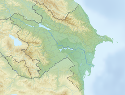
Mingachevir reservoir
| Mingachevir Reservoir | |
|---|---|
 Mingachevir Reservoir | |
| Location | Mingachevir |
| Coordinates | 40°47′20″N 47°01′40″E / 40.78889°N 47.02778°E |
| Type | reservoir |
| Primary inflows | Kura River, Alazani, Iori/Qabırlı |
| Primary outflows | Kura River |
| Basin countries | Azerbaijan |
| Built | 1953 |
| Max. length | 70 km (43 mi) |
| Max. width | 18 km (11 mi) |
| Surface area | 605 km2 (234 sq mi) |
| Average depth | 26 m (85 ft) |
| Max. depth | 75 m (246 ft) |
| Water volume | 15.730 km3 (12,753,000 acre⋅ft) |
| Shore length1 | 247 km (153 mi) |
| 1 Shore length is not a well-defined measure. | |
The Mingachevir reservoir (Azerbaijani: Mingəçevir su anbarı) (also known as the Mingachevir sea (Azerbaijani: Mingəçevir dənizi)) is a large reservoir on the Kura river in northwestern Azerbaijan.[1][2][3] It supplies water to the Upper Karabakh and Upper Shirvan channels, and is used for electricity generation, irrigation water supply, and fishing.
- ^ Ilʹin, Mikhail (1948). "От Черного до Каспийского моря".
- ^ Davydov, Mitrofan (1958). "От Волхова до Амура".
- ^ "Azərbaycan Milli Kitabxanası".
Previous Page Next Page


