Our website is made possible by displaying online advertisements to our visitors.
Please consider supporting us by disabling your ad blocker.
Monmouthshire
Monmouthshire
Sir Fynwy (Welsh) | |
|---|---|
| |
| Motto(s): | |
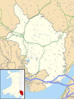
 Monmouthshire shown within Wales | |
| Coordinates: 51°47′N 2°52′W / 51.783°N 2.867°W | |
| Sovereign state | United Kingdom |
| Country | Wales |
| Preserved county | Gwent |
| Incorporated | 1 April 1996 |
| Administrative HQ | Usk |
| Government | |
| • Type | Principal council |
| • Body | Monmouthshire County Council |
| • Control | No overall control |
| • MPs | Catherine Fookes (L) |
| • MSs | +4 regional members |
| Area | |
• Total | 328 sq mi (849 km2) |
| • Rank | 7th |
| Population (2022)[2] | |
• Total | 93,886 |
| • Rank | 17th |
| • Density | 290/sq mi (111/km2) |
| Welsh language (2021) | |
| • Speakers | 8.7% |
| • Rank | 22nd |
| Time zone | UTC+0 (GMT) |
| • Summer (DST) | UTC+1 (BST) |
| ISO 3166 code | GB-MON |
| GSS code | W06000021 |
| Website | monmouthshire |
Monmouthshire (/ˈmɒnməθʃər, ˈmʌn-, -ʃɪər/ MON-məth-shər, MUN-, -sheer; Welsh: Sir Fynwy) is a county in the south east of Wales. It borders Powys to the north; the English counties of Herefordshire and Gloucestershire to the north and east; the Severn Estuary to the south, and Torfaen, Newport and Blaenau Gwent to the west. The largest town is Abergavenny, and the administrative centre is Usk. The county is administered by Monmouthshire County Council. It sends two directly-elected members to the Senedd at Cardiff and one elected member to the UK parliament at Westminster. The county name is identical to that of the historic county, of which the current local authority covers the eastern three-fifths. Between 1974 and 1996, the county was known as Gwent, recalling the medieval kingdom which covered a similar area. The present county was formed under the Local Government (Wales) Act 1994, which came into effect in 1996. In his essay 'Changes in local government', in the fifth and final volume of the Gwent County History, Robert McCloy writes, "the local government of no county in the United Kingdom in the twentieth century was so transformed as that of Monmouthshire".[4]
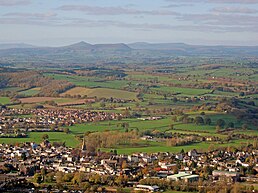
The lowlands in the centre of Monmouthshire are gently undulating, and shaped by the River Usk and its tributaries. The west of the county is hilly, and the Black Mountains in the northwest are part of the Brecon Beacons National Park (Bannau Brycheiniog). The border with England in the east largely follows the course of the River Wye and its tributary, the River Monnow. In the south east is the Wye Valley AONB, a hilly region which stretches into England. The county has a shoreline on the Severn Estuary, with crossings into England by the Severn Bridge and Second Severn Crossing.
The county is rural, although adjacent to the city of Newport and the urbanised South Wales Valleys; it has an area of 330 square miles (850 km2) and a population of 93,000. After Abergavenny (12,515), the largest towns are Chepstow (12,350), Monmouth (10,508), and Caldicot (9,813). The county has one of the lowest percentages of Welsh speakers in Wales, at 8.2% of the population in 2021. The county is among the more economically prosperous of the Welsh principal areas, with a predominantly service economy giving annual incomes of around £41,000 in 2020, some £9,000 above the Welsh average. Agriculture and tourism are other important economic sectors. Transport infrastructure is provided by the M4 and M48 motorways in the south of the county, linking Monmouthshire and Wales with England; and by rail links in the south and the north. Public services are mainly organised on a south east Wales region basis, including the South Wales Fire and Rescue Service, Gwent Police and the Aneurin Bevan University Health Board.
The Gwent Levels have signs of human occupation dating back eight millennia. At the time of the Roman invasion, the Silures, the dominant tribe in south-east Wales, carried out a thirty-year opposition to Roman occupation, but were eventually subdued, the Romans asserting their control through the establishment of fortified settlements such as Venta Silurum, modern-day Caerwent. The sub-Roman history of the county is poorly documented but saw the founding of petty kingdoms including that of Gwent. Monmouthshire's turbulent medieval history on the Welsh Marches is reflected in its "fine collection" of castles, including that at Chepstow, "one of the great strongholds of Europe". Henry V was born at Monmouth Castle in 1386. War in the county continued into the 17th century, Raglan Castle was among the last Royalist strongholds to fall to Parliamentarian forces in the English Civil War. Military disruption was followed by civil unrest: in the 17th century, the county was a recusant stronghold and saw widespread persecution of Catholics; in the 19th century, John Frost and other Chartist leaders were tried and sentenced to death at the Shire Hall, Monmouth after the "first mass movement of the working class" in Britain. The advent of a more stable society in the early 19th century saw the county develop as a centre for tourism; the Wye Tour down the river valley in the east of the county culminated for visitors with the ruins of Tintern Abbey. In the 20th and 21st centuries tourism and leisure continue as important foci for the county's population; Wales's richest horse race runs at Chepstow Racecourse; the Savoy Theatre, Monmouth has claims to be Wales's oldest; and Rockfield Studios has been used for recording sessions by some of the UK's biggest bands.
- ^ "Your Council". Monmouthshire County Council. June 2024. Retrieved 6 August 2024.
- ^ a b "Mid-Year Population Estimates, UK, June 2022". Office for National Statistics. 26 March 2024. Retrieved 3 May 2024.
- ^ "How life has changed in Monmouthshire: Census 2021". Office for National Statistics. 19 January 2023. Retrieved 6 August 2024.
- ^ McCloy 2013, p. 126.
Previous Page Next Page


