Our website is made possible by displaying online advertisements to our visitors.
Please consider supporting us by disabling your ad blocker.
Monto, Queensland
| Monto Queensland | |||||||||||||||
|---|---|---|---|---|---|---|---|---|---|---|---|---|---|---|---|
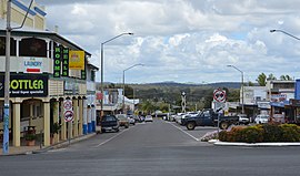
 Looking down Newtown Street to the Burnett Highway, 2017 | |||||||||||||||
| Coordinates | 24°51′51″S 151°07′24″E / 24.8641°S 151.1233°E | ||||||||||||||
| Population | 1,156 (2021 census)[1] | ||||||||||||||
| • Density | 19.527/km2 (50.57/sq mi) | ||||||||||||||
| Established | 1924 | ||||||||||||||
| Postcode(s) | 4630 | ||||||||||||||
| Elevation | 248.7 m (816 ft) | ||||||||||||||
| Area | 59.2 km2 (22.9 sq mi) | ||||||||||||||
| Time zone | AEST (UTC+10:00) | ||||||||||||||
| Location | |||||||||||||||
| LGA(s) | North Burnett Region | ||||||||||||||
| State electorate(s) | Callide | ||||||||||||||
| Federal division(s) | Flynn | ||||||||||||||
| |||||||||||||||
| |||||||||||||||
Monto /ˈmɒntoʊ/[2] is a rural town and locality in the North Burnett Region, Queensland, Australia.[3][4] In the 2021 census, the locality of Monto had a population of 1,156 people.[1]
- ^ a b Cite error: The named reference
Census2021was invoked but never defined (see the help page). - ^ Macquarie Dictionary, Fourth Edition (2005). Melbourne, The Macquarie Library Pty Ltd. ISBN 1-876429-14-3
- ^ "Monto – town in North Burnett Region (entry 22549)". Queensland Place Names. Queensland Government. Retrieved 16 November 2019.
- ^ "Monto – locality in North Burnett Region (entry 45391)". Queensland Place Names. Queensland Government. Retrieved 16 November 2019.
Previous Page Next Page


