Our website is made possible by displaying online advertisements to our visitors.
Please consider supporting us by disabling your ad blocker.
Moradabad district
Moradabad District | |
|---|---|
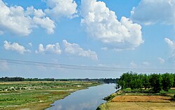
 Ramganga at Moradabad | |
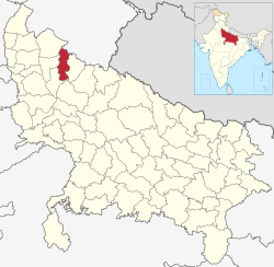
 Location of Moradabad district in Uttar Pradesh | |
| Coordinates (Moradabad): 28°50′N 78°46′E / 28.84°N 78.76°E | |
| Country | |
| State | Uttar Pradesh |
| Division | Moradabad |
| Headquarters | Moradabad |
| Government | |
| • Lok Sabha constituencies | Moradabad |
| • Vidhan Sabha constituencies | Barhapur Kanth Thakurdwara Moradabad Rural Moradabad Nagar |
| Area | |
• Total | 1,264.7 km2 (488.3 sq mi) |
| Population (2011) | |
• Total | 3,126,507 |
| • Density | 2,500/km2 (6,400/sq mi) |
| Demographics | |
| • Literacy | 58.67 per cent[1] |
| Time zone | UTC+05:30 (IST) |
| Website | moradabad |
Moradabad district (Hindi pronunciation: [mʊɾaːd̪aːbaːd̪]) is one of the districts of Uttar Pradesh, India. The city of Moradabad is the district headquarters. Moradabad district is part of Moradabad division. It used to be the second most populous district of Uttar Pradesh out of 75 after Prayagraj[2] till a new district Sambhal was carved out of it in 2011.
The district of Moradabad lies between 28°21´ to 28°16´ north latitude and 78°4´ to 79° east longitude.
- ^ "District-specific Literates and Literacy Rates, 2001". Registrar General, India, Ministry of Home Affairs. Retrieved 10 October 2010.
- ^ "District Census Handbook: Moradabad" (PDF). censusindia.gov.in. Registrar General and Census Commissioner of India. 2011.
Previous Page Next Page


