Our website is made possible by displaying online advertisements to our visitors.
Please consider supporting us by disabling your ad blocker.
Mount Hermon
| Mount Hermon | |
|---|---|
| Jabal ash-Shaykh جبل الشيخ (Arabic) Har Ḥermon הר חרמון (Hebrew) | |
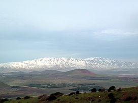
 Mount Hermon, viewed from Mount Bental in the Golan Heights | |
| Highest point | |
| Elevation | 2,814 m (9,232 ft)[1] |
| Prominence | 1,804 m (5,919 ft) |
| Listing | |
| Coordinates | 33°24′58″N 35°51′27″E / 33.41611°N 35.85750°E |
| Geography | |
| Location | Syria (The summit and southern slopes are Israeli-occupied) Lebanon |
| Parent range | Anti-Lebanon mountain range |

Mount Hermon (Arabic: جبل الشيخ / ALA-LC: Jabal al-Shaykh ('Mountain of the Sheikh', Levantine Arabic pronunciation: [ʒa.bal eʃ.ʃeːx]), Hebrew: הַר חֶרְמוֹן, Har Ḥermōn) is a mountain cluster constituting the southern end of the Anti-Lebanon mountain range. Its summit straddles the border between Syria and Lebanon[2] and, at 2,814 m (9,232 ft) above sea level, is the highest point in Syria.[3] On the top, in the United Nations buffer zone between Syrian and Israeli-occupied territories, is the highest permanently manned UN position in the world, known as "Hermon Hotel",[4] located at 2814 metres altitude (9,232 ft).[5] The southern slopes of Mount Hermon extend to the Israeli-occupied portion of the Golan Heights, where the Mount Hermon ski resort is located[6] with a top elevation of 2,040 metres (6,690 ft).[7] A peak located about 11 kilometres (6.8 mi) south-southwest of Mount Hermon, known as Mitzpe Hashlagim, is the highest point in the entirety of Israel and Israeli-occupied Golan Heights, at 2,236 m (7,336 ft).[8]
- ^ "Topographic map of Mount Hermon". opentopomap.org. Retrieved 2023-04-03.
- ^ "ACME Mapper terrain display". mapper.acme.com. Archived from the original on 6 October 2014. Retrieved 28 March 2016.
- ^ "CIA World Fact Book: Syria". 14 November 2011. Retrieved 27 November 2011.
highest point: Mount Hermon 2,814 m
- ^ Gröppel, Ekkehard (April–June 2013). "It is time to say Goodbye!" (PDF). Golan: The UNDOF Journal (135). United Nations Disengagement Observer Force: 10–15. Retrieved 15 July 2015.
- ^ "Mt Hermon – UNDOF's Vital Ground" (PDF). Golan: The UNDOF Journal (144). United Nations Disengagement Observer Force. July–September 2015. Retrieved 18 April 2019.
- ^ The World's 18 Strangest Ski Resorts: The Mount Hermon Ski Resort Archived 2014-10-06 at the Wayback Machine, Shannon Hassett, Popular Mechanics
- ^ The Hermon Ski Resort: About, homepage of the resort, accessed 9 August 2019
- ^ "Mitze Hashlagim - Peakbagger.com". www.peakbagger.com. Retrieved 2024-09-10.
Previous Page Next Page


