Our website is made possible by displaying online advertisements to our visitors.
Please consider supporting us by disabling your ad blocker.
Mount Jefferson Wilderness
| Mount Jefferson Wilderness | |
|---|---|
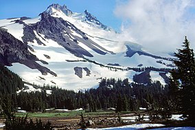
 Jefferson Park Meadows, Mount Jefferson Wilderness | |
| Location | Linn / Jefferson / Marion counties, Oregon, United States[1] |
| Nearest city | Sisters, Oregon |
| Coordinates | 44°40′31.05″N 121°47′54.40″W / 44.6752917°N 121.7984444°W |
| Area | 111,177 acres (449.9 km2) |
| Established | 1968 |
| Governing body | United States Forest Service |
The Mount Jefferson Wilderness is a wilderness area located on and around Mount Jefferson in the central Cascade Range of Oregon in the United States. The wilderness lies within the Willamette National Forest and Deschutes National Forest. The wilderness area covers 111,177 acres (449.92 km2), with more than 150 lakes. It also has 190 miles (310 km) of trails, including 40 miles (64 km) of the Pacific Crest National Scenic Trail.[2][3] Three Fingered Jack and Mount Jefferson are both prominent features of the wilderness area.[3] Mount Jefferson Wilderness is the second most visited Oregon wilderness area after the Three Sisters Wilderness.[4]
- ^ U.S. National Wilderness Preservation System Map (Map). Wilderness.net. Retrieved July 28, 2014.
- ^ "Mount Jefferson Wilderness". Deschutes National Forest. Archived from the original on July 8, 2018. Retrieved July 7, 2018.
- ^ a b "Mt. Jefferson Wilderness". Willamette National Forest. Archived from the original on July 8, 2018. Retrieved July 7, 2018.
- ^ Sullivan, William L. (2002). Thurman, Paula (ed.). Exploring Oregon's Wild Areas (3rd ed.). The Mountaineers Books.
Previous Page Next Page


