Our website is made possible by displaying online advertisements to our visitors.
Please consider supporting us by disabling your ad blocker.
Mount Macedon
| Mount Macedon | |
|---|---|
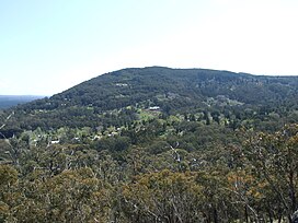
 Mount Macedon, above the town of Mount Macedon. | |
| Highest point | |
| Elevation | 1,001 metres (3,284 ft)[1] |
| Prominence | 643 metres (2,110 ft)[1] |
| Parent peak | Camel's Hump or Camels Hump |
| Coordinates | 37°22′59″S 144°34′35″E / 37.38306°S 144.57639°E[2] |
| Naming | |
| Native name |
|
| Geography | |
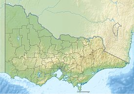
Location in Victoria | |
| Location | Central Highlands, Victoria, Australia |
| Parent range | Macedon Ranges, Great Dividing Range |
| Climbing | |
| First ascent | Thomas Mitchell (European: 1836)[3] |
Mount Macedon (/ˈmæsədən/ MASS-ə-dən;[4] Aboriginal Woiwurrung language: Geboor or Geburrh)[3] is a dormant volcano that is part of the Macedon Ranges of the Great Dividing Range, located in the Central Highlands region of Victoria, Australia. The mountain has an elevation of 1,001 metres (3,284 ft) with a prominence of 643 metres (2,110 ft)[1] and is located approximately 65 kilometres (40 mi) northwest of Melbourne.
- ^ a b c "Mount Macedon, Australia". Peakbagger.com.
- ^ "Mount Macedon". Gazetteer of Australia online. Geoscience Australia, Australian Government.
- ^ a b Milbourne, Jean (1978), Mount Macedon: Its History and its Grandeur, Kyneton, Victoria: (self published), pp. 10, 14, ISBN 0-9595225-0-6
- ^ Macquarie Dictionary (4th ed.). Melbourne, Victoria: The Macquarie Library Pty Ltd. 2005. ISBN 1-876429-14-3.
Previous Page Next Page


