Our website is made possible by displaying online advertisements to our visitors.
Please consider supporting us by disabling your ad blocker.
Mount Mitchell
| Mount Mitchell | |
|---|---|
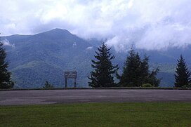
 Mount Mitchell, viewed from the Blue Ridge Parkway in North Carolina | |
| Highest point | |
| Elevation | 6,684 ft (2,037 m)[1] |
| Prominence | 6,089 ft (1,856 m)[1] |
| Isolation | 1,189 miles (1,914 km) |
| Listing | |
| Coordinates | 35°45′53″N 82°15′54″W / 35.764839°N 82.2651221°W[2] |
| Geography | |
| Location | Yancey County, North Carolina, U.S. |
| Parent range | Appalachian Mountains |
| Topo map | USGS Mount Mitchell |
| Climbing | |
| Easiest route | Hike |
Mount Mitchell (Attakulla in Cherokee)[3] is the highest peak of the Appalachian Mountains and the highest peak in mainland North America east of the Mississippi River. It is located near Burnsville in Yancey County, North Carolina in the Black Mountain subrange of the Appalachians about 19 miles (31 km) northeast of Asheville. It is protected by Mount Mitchell State Park and surrounded by the Pisgah National Forest. Mount Mitchell's elevation is 6,684 feet (2,037 m) above sea level.[1] Mount Mitchell is ranked 31st by topographic isolation.
- ^ a b c "Mount Mitchell, North Carolina". Peakbagger.com. Retrieved 2008-12-28.
- ^ "Mount Mitchell". Geographic Names Information System. United States Geological Survey, United States Department of the Interior. Retrieved 2008-12-28.
- ^ Bradford, Erin (2019-12-05). "North Carolina Gazetteer". NCpedia. Archived from the original on 2021-01-14. Retrieved 2020-11-22.
Previous Page Next Page


