Our website is made possible by displaying online advertisements to our visitors.
Please consider supporting us by disabling your ad blocker.

Mount Pleasant (Washington, D.C.)
Mount Pleasant | |
|---|---|
&sq=&lang=en&file=File:Mount_Pleasant_library_(4356776281)_(cropped).jpg) &sq=&lang=en&file=File:Mount_Pleasant_Historic_District_(cropped).jpg) &sq=&lang=en&file=File:Mount_Pleasant_Street_NW_(cropped).jpg)  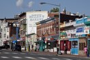 Top: Mt. Pleasant Library (left) and Victorian townhomes (right); middle: Mt. Pleasant Street; bottom: Francis Asbury Memorial (left) and Mt. Pleasant St (right). | |
&sq=&lang=en&file=File:DC_Neighborhoods_-_Mount_Pleasant.svg) Map of Washington, D.C., with Mount Pleasant highlighted in maroon. | |
| Coordinates: 38°55′43.3″N 77°2′14.4″W / 38.928694°N 77.037333°W | |
| Country | United States |
| District | Washington, D.C. |
| Quadrant | Northwest |
| Ward | 1 |
Mount Pleasant is a neighborhood in Washington, D.C., located in Northwest D.C. The neighborhood is primarily residential, with restaurants and stores centered along a commercial corridor on Mt. Pleasant Street. Mount Pleasant is known for its unique identity and multicultural landscape, home to diverse groups such as the punk rock, the Peace Corps and Hispanic Washingtonian communities.[1]
The neighborhood was initially developed around the Mount Pleasant Hospital, which was built and operated during the American Civil War. Following the war, the largely rural was subdivided for real estate development. Following the advent of the D.C. streetcar system, Mt. Pleasant became Washington's first streetcar suburb and burgeoned as an affluent residential area until the mid-1940s. The neighborhood entered a period of decay following the white flight and the 1968 Washington, D.C. riots. Since the 2000s, Mount Pleasant has undergone increasing urban redevelopment and levels of gentrification.[2][3]
Previous Page Next Page

