Our website is made possible by displaying online advertisements to our visitors.
Please consider supporting us by disabling your ad blocker.
Mount Unzen
| Mount Unzen | |
|---|---|
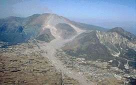
 Mt. Unzen, showing extensive pyroclastic flow and lahar deposits | |
| Highest point | |
| Elevation | 1,486 m (4,875 ft) |
| Coordinates | 32°45′41″N 130°17′55″E / 32.76139°N 130.29861°E |
| Geography | |
Unzen, Nagasaki, Kyushu, Japan | |
| Geology | |
| Rock age | Oldest 500 kyr[1] |
| Mountain type | Complex stratovolcano |
| Last eruption | February to May 1996 |

Mount Unzen (雲仙岳, Unzen-dake) is an active volcanic group of several overlapping stratovolcanoes, near the city of Shimabara, Nagasaki on the island of Kyushu, Japan's southernmost main island.
In 1792, the collapse of one of its several lava domes triggered a megatsunami that killed 14,524 people in Japan's worst volcanic-related disaster. The volcano was most recently active from 1990 to 1995, and a large eruption in 1991 generated a pyroclastic flow that killed 43 people, including three volcanologists.
Its highest peaks are Fugen-dake (普賢岳) at 1,359 metres (4,459 ft) and Heisei-shinzan (平成新山) at 1,486 metres (4,875 ft). The latter emerged during the eruptions of the early, eponymous Heisei era (1989–2019).
- ^ "Geological Background of Unzen Volcano". Archived from the original on 2006-04-29. Retrieved 2006-04-10.
Previous Page Next Page


