Our website is made possible by displaying online advertisements to our visitors.
Please consider supporting us by disabling your ad blocker.
Naab
| Naab | |
|---|---|
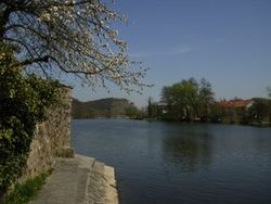
 The Naab near Kallmünz | |
 | |
| Location | |
| Country | Germany |
| State | Bavaria |
| Physical characteristics | |
| Source | |
| • location | Fichtel Mountains |
| Mouth | |
• location | Danube |
• coordinates | 49°1′0″N 12°1′53″E / 49.01667°N 12.03139°E |
| Length | 97.5 km (61 mi) [1] |
| Basin size | 5,514 km2 (2,129 sq mi) [1] |
| Discharge | |
| • location | mouth |
| • average | 49 m3/s (1,700 cu ft/s) |
| Basin features | |
| Progression | Danube→ Black Sea |
The Naab (Czech: Nába) is a river in Bavaria, Germany.
This 97.5 kilometer long river is a left tributary of the Danube. Its average discharge at the mouth is 49 m3/s (1,700 cu ft/s).[1][2]
The Naab is formed by the confluence of the Waldnaab and the Haidenaab in Luhe-Wildenau, south of Weiden in der Oberpfalz. It flows generally south, through the towns Nabburg, Schwandorf and Burglengenfeld. It flows into the Danube near Regensburg.
- ^ a b c Complete table of the Bavarian Waterbody Register by the Bavarian State Office for the Environment (xls, 10.3 MB)
- ^ "Danube River Basin District, Part A - Roof Report" (PDF). ICPDR. April 2004. p. 12.
Previous Page Next Page


