Our website is made possible by displaying online advertisements to our visitors.
Please consider supporting us by disabling your ad blocker.
Namib
| Namib | |
|---|---|
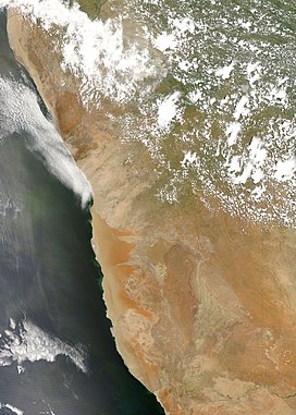
 An image of the Namib Desert by the MODIS instrument | |
 Approximate boundaries of the Namib Desert | |
| Length | 1,600 km (990 mi) |
| Width | 50–160 km (31–99 mi) |
| Area | 160,000 km2 (62,000 sq mi) |
| Geography | |
| Countries |
|
| Coordinates | 24°45′07″S 15°16′35″E / 24.75194°S 15.27639°E |
| Rivers | List
|
| Official name | Namib Sand Sea |
| Criteria | Natural: vii, viii, ix, x |
| Reference | 1430 |
| Inscription | 2013 (37th Session) |
| Area | 3,077,700 ha |
| Buffer zone | 899,500 ha |
The Namib (/ˈnɑːmɪb/ NAH-mib;[1] Portuguese: Namibe) is a coastal desert in Southern Africa. According to the broadest definition, the Namib stretches for more than 2,000 kilometres (1,200 mi) along the Atlantic coasts of Angola, Namibia, and northwest South Africa, extending southward from the Carunjamba River in Angola, through Namibia and to the Olifants River in Western Cape, South Africa.[2][3][4] The Namib's northernmost portion, which extends 450 kilometres (280 mi) from the Angola-Namibia border, is known as Moçâmedes Desert, while its southern portion approaches the neighboring Kalahari Desert. From the Atlantic coast eastward, the Namib gradually ascends in elevation, reaching up to 200 kilometres (120 mi) inland to the foot of the Great Escarpment.[2] Annual precipitation ranges from 2 millimetres (0.079 in) in the aridest regions to 200 millimetres (7.9 in) at the escarpment, making the Namib the only true desert in southern Africa.[2][4][5] Having endured arid or semi-arid conditions for roughly 55–80 million years, the Namib may be the oldest desert in the world[2][5] and contains some of the world's driest regions, with only western South America's Atacama Desert to challenge it for age and aridity benchmarks.[A]
The desert geology consists of sand seas near the coast, while gravel plains and scattered mountain outcrops occur further inland. The sand dunes, some of which are 300 metres (980 ft) high and span 32 kilometres (20 mi) long, are the second-largest in the world after the Badain Jaran Desert dunes in China.[2] Temperatures along the coast are stable and generally range between 9–20 °C (48–68 °F) annually, while temperatures further inland are variable—summer daytime temperatures can exceed 45 °C (113 °F) while nights can be freezing.[7] Fogs that originate offshore from the collision of the cold Benguela Current and warm air from the Hadley cell create a fog belt that frequently envelops parts of the desert. Coastal regions can experience more than 180 days of thick fog a year.[2][5] While this has proved a major hazard to ships—more than a thousand wrecks litter the Skeleton Coast—it is a vital source of moisture for desert life.
The Namib is almost completely uninhabited by humans except for several small settlements and indigenous pastoral groups, including the Ovahimba and Obatjimba Herero in the north, and the Topnaar Nama in the central region.[4] Owing to its antiquity, the Namib may be home to more endemic species than any other desert in the world.[7] Most of the desert wildlife is arthropods and other small animals that live on little water, although larger animals inhabit the northern regions. Near the coast, the cold ocean water is rich in fishery resources and supports populations of brown fur seals and shorebirds, which serve as prey for the Skeleton Coast's lions.[7] Further inland, the Namib-Naukluft National Park supports population of mountain zebras, and other large mammals. Further north near the Skeleton Coast, lions, elephants and rhinos can be found. Although the outer Namib is largely barren of vegetation, lichens and succulents are found in coastal areas, while grasses, shrubs, and ephemeral plants thrive near the escarpment. Several types of trees are also able to survive the extremely arid climate.[7]
- ^ "Namib Desert". Lexico UK English Dictionary. Oxford University Press. Archived from the original on 2022-07-29.
- ^ a b c d e f Goudie, Andrew (2010). "Chapter 17: Namib Sand Sea: Large Dunes in an Ancient Desert". In Migoń, Piotr (ed.). Geomorphological Landscapes of the World. New York, NY: Springer. pp. 163–169. ISBN 978-90-481-3054-2.
- ^ Stone, A. E. C. (2013-06-01). "Age and dynamics of the Namib Sand Sea: A review of chronological evidence and possible landscape development models". Journal of African Earth Sciences. 82: 70–87. Bibcode:2013JAfES..82...70S. doi:10.1016/j.jafrearsci.2013.02.003. ISSN 1464-343X.
- ^ a b c Gates, Henry Louis; Appiah, Kwame Anthony, eds. (2010). Encyclopedia of Africa. Vol. 2. Oxford: Oxford University Press. p. 213. ISBN 978-0-19-533770-9.
- ^ a b c Spriggs, Amy. "Namib desert (AT1315)". Wild World. World Wildlife Fund. Retrieved 11 December 2011.
- ^ Veloso, José Vicencio; Böhm, Christoph; Schween, Jan H.; Löhnert, Ulrich; Crewell, Susanne (2024). "A comparative study of the atmospheric water vapor in the Atacama and Namib Desert". Global and Planetary Change. 232. doi:10.1016/j.gloplacha.2023.104320.
- ^ a b c d Nicholson, Sharon E. (2011). Dryland Climatology. Cambridge: Cambridge University Press. pp. 385–388. ISBN 978-0-521-51649-5. Retrieved 13 December 2011.
Cite error: There are <ref group=upper-alpha> tags or {{efn-ua}} templates on this page, but the references will not show without a {{reflist|group=upper-alpha}} template or {{notelist-ua}} template (see the help page).
Previous Page Next Page


