Our website is made possible by displaying online advertisements to our visitors.
Please consider supporting us by disabling your ad blocker.
Nangarhar Province
Nangarhar Province
ننگرهار | |
|---|---|
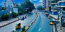
 Street in Jalalabad city | |
 Map of Afghanistan with Nangarhar highlighted | |
| Coordinates (Capital): 34°15′N 70°30′E / 34.25°N 70.50°E | |
| Country | |
| Capital | Jalalabad |
| Government | |
| • Governor | Hajji Gul Mohammad[1] |
| • Deputy Governor | Maulvi Niaz Mohammad Wahaj[2] |
| • Police Chief | Neda Mohammad |
| Area | |
• Total | 7,727 km2 (2,983 sq mi) |
| Population (2021)[3] | |
• Total | 1,735,531 |
| • Density | 220/km2 (580/sq mi) |
| Time zone | UTC+4:30 (Afghanistan Time) |
| Postal code | 26XX |
| ISO 3166 code | AF-NAN |
| Main languages | Pashto, Dari |
Nangarhār (Pashto: ننګرهار; Dari: ننگرهار), also called Nangrahar or Ningrahar, is one of the 34 provinces of Afghanistan, located in the eastern part of the country and bordering Logar, Kabul, Laghman and Kunar provinces as well as having an international border with Pakistan. It is divided into 22 districts and has a population of about 1,735,531,[3] the third highest of the country's 34 provinces. The city of Jalalabad is the capital of Nangarhar province. Nangarhar province is famous for its fish and karahi dishes.[4]
- ^ "Taliban appoint new leaders of two provinces in Eastern Afghanistan after deadly attacks". The Nation. 21 September 2021. Archived from the original on 29 November 2022. Retrieved 24 September 2021.
- ^ "ننګرهارکې پر خواوشاه دوه زره کورنیو نغدې او ژمنۍ مرستې وویشل شوې نور حال په راپور کښې". 20 December 2021. Archived from the original on 5 January 2022. Retrieved 5 January 2022.
- ^ a b "Estimated Population of Afghanistan 2021-22" (PDF). National Statistic and Information Authority (NSIA). April 2021. Archived (PDF) from the original on 24 June 2021. Retrieved 21 June 2021.
- ^ "Picnic Along Kabul-Nangarhar Attractions". ARCH International.[permanent dead link]
Previous Page Next Page


