Our website is made possible by displaying online advertisements to our visitors.
Please consider supporting us by disabling your ad blocker.
Narsipatnam
This article possibly contains original research. (January 2024) |
Narsipatnam | |
|---|---|
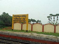
 Narsipatnam Road railway station | |
| Coordinates: 17°39′54″N 82°36′50″E / 17.665°N 82.614°E | |
| Country | India |
| State | Andhra Pradesh |
| District | Anakapalle |
| Government | |
| • Type | Municipality |
| • Body | Narsipatnam Municipality VMRDA |
| • MLA | Chintakayala ayyanna patrudu |
| Area | |
• Total | 42.00 km2 (16.22 sq mi) |
| Elevation | 58 m (190 ft) |
| Population (2011)[2] | |
• Total | 61,540 |
| • Density | 1,500/km2 (3,800/sq mi) |
| Languages | |
| • Official | Telugu |
| Time zone | UTC+5:30 (IST) |
| PIN | 531116 |
| Vehicle Registration | AP31 (Former) AP39 (from 30 January 2019)[3] |
Narsipatnam is a census town in Anakapalle district of the Indian state of Andhra Pradesh. It was upgraded from a gram panchayat into municipality in 2012.[4] The town is spread over an area of 42 km2 (16 sq mi) The resting place of the revolutionary Indian freedom fighter Alluri Sitarama Raju is located in Krishna Devi Peta village of From Narsipatnam to labasingi Village 30 km only.. labasingi most popular winter tourism place..so many Tourists enjoy -2 degree's temparature there.. Narsipatnam town is 43 km away from Tuni. And it is 72 km away from Visakhapatnam.
- ^ "Municipalities, Municipal Corporations & UDAs" (PDF). Directorate of Town and Country Planning. Government of Andhra Pradesh. Archived from the original (PDF) on 28 January 2016. Retrieved 29 January 2016.
- ^ "Census 2011". The Registrar General & Census Commissioner, India. Retrieved 1 September 2014.
- ^ "New 'AP 39' code to register vehicles in Andhra Pradesh launched". The New Indian Express. Vijayawada. 31 January 2019. Archived from the original on 28 July 2019. Retrieved 9 June 2019.
- ^ Object, object (26 September 2016). "Narsipatnam still a 'panchayat'". www.thehansindia.com. Retrieved 12 June 2019.
Previous Page Next Page


