Our website is made possible by displaying online advertisements to our visitors.
Please consider supporting us by disabling your ad blocker.
Nasirabad District
Naseerabad District
ضلع نصیر آباد | |
|---|---|
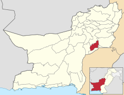
 Map of Balochistan with Nasirabad District highlighted | |
| Country | |
| Province | |
| Division | Nasirabad |
| Established | 1974 |
| Named for | Mir Nasir Khan I |
| Headquarters | Dera Murad Jamali |
| Administrative Tehsil | 06
|
| Government | |
| • Type | District Administration |
| • Deputy Commissioner | Munir Ahmed Khan Kakar |
| • Constituensy | NA-254 Nasirabad-cum-Kachhi-cum-Jhal Magsi |
| • National Assembly Member | Khalid Hussain Magsi (BAP) |
| Area | |
• District of Balochistan | 3,387 km2 (1,308 sq mi) |
| Elevation | 67 m (220 ft) |
| Population (2023)[1] | |
• District of Balochistan | 563,315 |
| • Density | 170/km2 (430/sq mi) |
| • Urban | 106,952 (19.7%) |
| • Rural | 456,363 |
| Time zone | UTC+05:00 (PKT) |
| • Summer (DST) | DST is not observed |
| ZIP Code | |
| NWD (area) code | 0838 |
| ISO 3166 code | PK-BA |
| CNIC Code Nasirabad District | 53402-XXXXXXX-X |
Nasirabad (Urdu: ضلع نصیر آباد) is a district of Nasirabad Division in Balochistan, Pakistan. The District was notified in 1974 by separating from Kalat District. For three years, it was called Tamboo District from July 1987 to December 1990, The district's headquarters are located at Dera Murad Jamali. According to 2023 Pakistani census population of Nasirabad District is 565,315.
Previous Page Next Page


