Our website is made possible by displaying online advertisements to our visitors.
Please consider supporting us by disabling your ad blocker.
Niederanven
This article needs additional citations for verification. (December 2007) |
Niederanven
Nidderaanwen | |
|---|---|
 | |
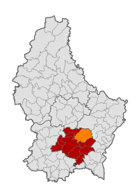
 Map of Luxembourg with Niederanven highlighted in orange, and the canton in dark red | |
| Coordinates: 49°39′05″N 6°15′20″E / 49.6514°N 6.2556°E | |
| Country | |
| Canton | Luxembourg |
| Government | |
| • Mayor | Frédéric Ternes |
| Area | |
• Total | 41.36 km2 (15.97 sq mi) |
| • Rank | 12th of 100 |
| Highest elevation | 429 m (1,407 ft) |
| • Rank | 28th of 100 |
| Lowest elevation | 241 m (791 ft) |
| • Rank | 47th of 100 |
| Population (2023) | |
• Total | 6,660 |
| • Rank | 23rd of 100 |
| • Density | 160/km2 (420/sq mi) |
| • Rank | 21st of 100 |
| Time zone | UTC+1 (CET) |
| • Summer (DST) | UTC+2 (CEST) |
| LAU 2 | LU0000305 |
| Website | niederanven.lu |
Niederanven (Luxembourgish: Nidderaanwen [nidəˈʀaːnvən] ⓘ; German: Niederanwen) is a commune Luxembourg, located north-east of Luxembourg City, and derives its name from principal town, Niederanven. As of 2023[update], it has a population of 6,660.
The commune of Niederanven is the intersection for the A1 motorway and N1. Luxembourg Airport is located within the boundaries of the communes Niederanven and Sandweiler.
Previous Page Next Page


