Our website is made possible by displaying online advertisements to our visitors.
Please consider supporting us by disabling your ad blocker.
Nii-jima
This article needs additional citations for verification. (August 2022) |
Native name: 新島 | |
|---|---|
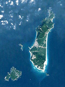
 Shikine-jima and Nii-jima | |
 | |
| Geography | |
| Location | Izu Islands |
| Coordinates | 34°22′N 139°16′E / 34.367°N 139.267°E |
| Archipelago | Izu Islands |
| Area | 23.87 km2 (9.22 sq mi) |
| Length | 11,000 m (36000 ft) |
| Width | 3,000 m (10000 ft) |
| Highest elevation | 432 m (1417 ft) |
| Administration | |
Japan | |
| Prefecture | Tokyo |
| Subprefecture | Ōshima Subprefecture |
| Village | Niijima |
| Demographics | |
| Population | 2700 (September 2009) |
| Additional information | |
 | |
Nii-jima (新島) is a volcanic Japanese island[1] administered by the Tokyo Metropolitan Government. It is one of the Izu Seven Islands, group of the seven northern islands of the Izu archipelago, and is located approximately 163 kilometres (101 mi) south of Tōkyō and 36 kilometres (22 mi) south of Shimoda Shizuoka Prefecture. The island is the larger inhabited component of the village of Niijima Village, Ōshima Subprefecture of Tokyo Metropolis, which also contains the neighboring island of Shikine-jima and the smaller, uninhabited Jinai-tō. Nii-jima is also within the boundaries of the Fuji-Hakone-Izu National Park.
On the southern tip of Nii-jima, there was formerly a launch site for experimental and sounding rockets.
- ^ Nussbaum, Louis-Frédéric. (2005). "Izu Shotō," Japan Encyclopedia, p. 412.
Previous Page Next Page


