Our website is made possible by displaying online advertisements to our visitors.
Please consider supporting us by disabling your ad blocker.
Nodaway River
| Nodaway River | |
|---|---|
 A section of the Lewis and Clark map of 1814 showing the rivers of northwest Missouri. The Nodaway is spelled "Nodawa". | |
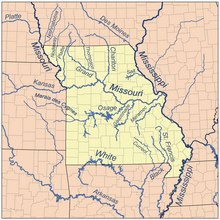
 Map of Missouri rivers. | |
| Native name | Nyi At'ąwe (Iowa-Oto) |
| Location | |
| Country | US |
| State | Iowa, Missouri |
| District | Page County, Iowa, Holt County, Missouri, Nodaway County, Missouri, Andrew County, Missouri |
| Physical characteristics | |
| Source | |
| • location | Clarinda, Iowa, US |
| • coordinates | 40°38′06″N 95°01′08″W / 40.635°N 95.019°W |
| • elevation | 945 ft (288 m) |
| Mouth | Missouri River |
• location | Amazonia, Missouri, US |
• coordinates | 39°54′07″N 94°57′58″W / 39.902°N 94.966°W |
• elevation | 827 ft (252 m) |
| Discharge | |
| • location | Graham, MO |
| • average | 1,008 cu/ft. per sec.[1] |
| Basin features | |
| Tributaries | |
| • left | West Nodaway River |
| • right | East Nodaway River |
| "USGS Geographic Names Information System". Retrieved 17 September 2009. | |


The Nodaway River is a 65.7-mile-long (105.7 km)[2] tributary that flows from southwest Iowa through northwest Missouri into the Missouri River.
- ^ "USGS Surface Water data for Missouri: USGS Surface-Water Annual Statistics".
- ^ U.S. Geological Survey. National Hydrography Dataset high-resolution flowline data. The National Map Archived 2012-03-29 at the Wayback Machine, accessed March 30, 2011
Previous Page Next Page


